RockWorks | Utilities | Solid |
Boolean Operations | Maximum Waste Thickness
This program reads a Boolean model and allows you to remove small pockets of "non-ore" material from surrounding "ore" blocks, translating them to "ore" classification and including them in the output solid model for future calculations. (This is the same as the "interbed" filter within the Borehole Manager's I-Data Volumetrics option.)
Menu Options
Step-by-Step Summary
Menu Options
- Boolean Input Model: Click to the right to browse for the name of the existing Boolean solid model that the program is to read and filter.
! This must be a Boolean (not a real number) model. See the Applying a Boolean Filter to a Solid Model option for information.
- Boolean Output Model: Click to the right to type in the name to assign to the new Boolean solid model that the program will create, which results from the filtering operation.
- Constraining Surface: Insert a check in this box if the computations are to be only for solid model nodes that lie below a grid (usually representing ground) surface. You can leave this box un-checked if the computations can include all nodes to the top of the model.
- If activated, expand this heading to select the grid model that contains the elevations for the surface topography.
- ! This grid model must already exist, and it must have the same X, Y dimensions and node spacing as the Boolean model being filtered.
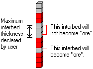
- Maximum Interbed Thickness: Here, type in the maximum thickness, in your depth or elevation units, to be considered as interbeds. Any contiguous "waste" voxels with a height less than this entry will be reassigned an "ore" classification and set to a value of "1".
- Create 3-Dimensional Diagram: Insert a check here if you want to create a plottable 3D diagram of the resulting solid model. Expand this item to establish the diagram settings.
- Diagram Type: Choose Isosurface to display the solid model as if enclosed in a "skin". Choose All Voxels to display color-coded voxels. (More.)
- Iso-Mesh: Use this option to plot a series of polylines that represent three-dimensional contours at a user-defined cutoff. Expand the heading to establish the settings. (More.)
- Color Scheme: Click on the Options button to the right to access a variety of pre-set color schemes, or to create your own. For this Boolean model, you can choose "2 Logical Colors" to assign a specific color for the "0" and "1" nodes. (More.)
- Reference Cage: Insert a check here to include vertical elevation axes and X and Y coordinate axes in the 3D diagram. Expand this item to set up the cage items. (More.)
- Include Legend: Insert a check here to include an index to the colors and G values in the diagram. (More.)
Step-by-Step Summary
- Be sure you have an existing Boolean solid model already created, for input into this program.
- Access the RockWorks Utilities program tab. It is not necessary to enter data into the main datasheet because RockWorks will be manipulating an existing model.
- Select the Solid | Boolean Operations | Maximum Waste Thickness menu option.
- Enter the requested menu settings, described above.
- Click the Process button to continue.
The program will read the input Boolean solid model file. If requested it will determine which nodes fall below the input ground surface grid and use only those nodes in the computations. It will scan each vertical column of voxels within the model, and determine which areas are "interbeds" by locating "waste" nodes that lie between "ore" nodes.
It then determines the thickness or height of the contiguous interbed (waste) nodes. Those areas where the thickness falls below your threshold are changed from "waste" to "ore." Those interbed thickness areas greater than your threshold remain interbeds. The filtered model will be stored under the requested output file name. If you have requested a diagram, it will be displayed in a RockPlot3D tab.
- You can adjust any of the input options along the left side of the window and click the Process button again to regenerate the model and display.
! Each time you click the Process button, the existing 3D display will be replaced.
- View / save / manipulate / print the diagram in the RockPlot3D window.
See also: The "Convert total ore thickness to a grid model" tool if you wish to convert this Boolean model to a grid model for display as a 2D contour map.
Example: Let’s say you are computing gravel reserves (solid model G value = percent gravel). During the computation process, the program creates a solid model of the gravel distribution in your study area, and it creates a Boolean model of the "gravel" and "not-gravel" areas. If you were to cut into the model, there might be small lenses of "not-gravel" that lie within larger areas of contiguous gravel. Using this filter, you can tell the program that if a lens or interbed exists that is less than a specified thickness, it can be considered as gravel.
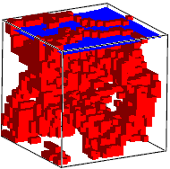
The picture below shows an imaginary cross section showing sand lenses (light blue) within a gravel bed (dark gray). Those sand interbeds (or portions of interbeds) with thickness less than the Maximum Total Waste Thickness you enter can be reclassified as gravel and included in output model and future calculations.

 Back to Solid Menu Summary

RockWare home page