The Rules & Filters pane is visible along the right side of many RockWorks program menus which process spatial data (anything with X and Y and/or Z coordinates), date-based data (T-Data, Aquifer tools), and/or stratigraphy data (all menus with striplogs or stratigraphy tools).
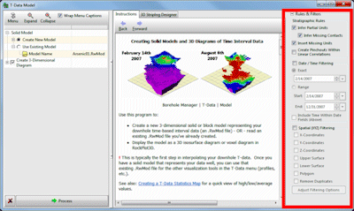
The options which are available are specific to the program window. For example, if you are creating a Utilities | Map | EZ Map, you'll only see the Spatial (XYZ) Filtering options. If you are creating a T-Data | Model in the Borehole Manager, you will see all of the options.
Here's a summary of the rules and filters which are available, with links to more information.
- Stratigraphic Rules: Use these settings to tell RockWorks how to handle missing stratigraphic data.
- Infer Partial Units:
 If checked, the program will try to determine a missing top or base depth for a formation based on overlying or underlying strata which are defined. (See more details.)
 If unchecked, the program will plot the data as-is in logs and sections.
! This setting DOES NOT require that the Stratigraphy Types table be ordered (with formations properly sequenced from the ground downward).
- Infer Missing Contacts: This sub-option (if Infer Partial Units is activated) can plot the contacts for partial units midway between the available top and base. (See more details.)
! This settings DOES require that the Stratigraphy Types Table be ordered.
- Insert Missing Units:
If checked, the program will assume that formations which are missing entirely at a contact can be pinched out at that location. The program will insert them into proper sequence, with zero thickness. (See more details.)
! This settings DOES require that the Stratigraphy Types Table be ordered.
! Don't activate this setting if you have already manually entered the missing units into the database. (See Missing Formations, Zero-Thickness Formations.)
- Create Pinchouts within Linear Correlations:
If checked: If a correlation cannot be made between a borehole interval and an adjacent borehole, the program will compute the midpoint between the two boreholes and construct a triangle that extends halfway from the defined interval and the borehole where the unit is not listed. (See more details.)
If unchecked, nothing will be drawn between the borehole that contains the stratigraphic interval and the borehole that does not.
- Date / Time Filtering: Use these settings to turn on/off filters for date-specific data. (See more details.)
- Exact: Choose this option to process data for a single date only; pick the date from the pop-up calendar.
- Range: Choose this option to process data for a range of dates; pick the starting and ending dates.
- Include Time within Date Fields (Above): Check this box if your dates include time notations that need to be included in the above filters.
! Note - If you include times, the Exact filter may not work as expected; you may get more accurate results with a specific range which includes the desired time.
- Spatial (XYZ) Filtering: Use these settings to turn on/off filters for spatial data.
! You must use the Adjust Filtering Settings button to define the filter specifics. (See more details.)
- X-Coordinates: Check this to limit processing to data points within a specific east-west range. Click the Adjust Filtering Settings button to define the coordinates.
- Y-Coordinates: Check this to limit processing to data points within a specific north-south range. Click the Adjust Filtering Settings button to define the coordinates.
- Z-Coordinates: Check this to limit processing to data points within a specific elevation range. Click the Adjust Filtering Settings button to define the coordinates.
- Upper Surface: Activate this setting to ignore data that lies above a designated surface (grid model). Click the Adjust Filtering Settings button to define the grid file name.
- Lower Surface: Activate this setting to ignore data that lies below a designated surface (grid model). Click the Adjust Filtering Settings button to define the grid file name.
- Polygon: Check this to limit processing to data points that lie either inside or outside a polygonal area. Click the Adjust Filtering Settings button to select the Polygon Table to be used.
- Remove Duplicates: Check this box to remove duplicate XYZ entries prior to processing.

RockWare home page