


RockWorks offers the following options for two dimensional maps. An option is activated if a check-mark is displayed in its check box. To access the item's settings, expand its sub-topics by clicking on its "+" button.
Click on a picture or link below for more information. See also the program dialog boxes for information on how to set up these different layers.
|
Background Image: Displays a bitmap image in the background of the other map layers. |
|
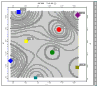
Symbols: Illustrates the sample locations with map symbols. |
|
Labels: Plots labels for the sample sites, usually used with the symbols layer. |
|
Contour Lines: Plots lines representing the distribution of "z-values" (elevation, geochemistry, etc.) in the study site. |
|
Color Intervals: Plots solid color-filled regions representing the distribution of z-values in the study site. |
|
Fault Polylines: (Available only for grid-based maps.) Displays any fault lines stored in the grid model. |
|
Labeled-Cells: (Available only for grid-based maps.) Draws a grid of lines corresponding to the grid model nodes, and fills the cells with labels for the node values. |
|
Border: Plots border tick marks and coordinates labels, and axis titles. |
|
Triangulation Network: (Available only for EZ maps, if contours or color filled intervals are selected.) Displays the network of triangles constructed by the program to build the map contours. |
![]()