
RockWorks | Utilities | File | Import | DXF (AutoCAD Lines and Points)
This program is used to import into the Utilities datasheet points from contour maps in AutoCAD (or other software) that have been saved in a DXF format. This can be an effective way to get the data that’s represented in a contour map into RockWorks. You might imagine this process as an automatic means of digitizing the contour lines into the program since it’s the contour line segment endpoints (XYZ) that will be listed in the datasheet.
This tool imports XYZ points from the following DXF entities: POINT, GEO-POINT, LINE, POLYLINE, and LWPOLYLINE
Menu Options
Step-by-Step Summary
Menu Options
- Output Columns
- X (Easting): Click on this item to select the name of the column in the datasheet into which the X (Easting) coordinates for the polyline vertex points are to be listed.
- Y (Northing): Click on this item to select the name of the column in the datasheet into which the Y (Northing) Cartesian coordinates are to be listed.
- Z (Elevation): Select the column in which to store the Z (elevation) data for the vertex points.
- Input File: Click to browse for the name of DXF file that contains entities that are to be scanned for XYZ data.
- Starting Row: Choose the row within datasheet that will contain the first xyz data point.
- Decimation Interval: This setting is used to reduce the number of points to be imported, which can be helpful if you intend to re-grid the XYZ points. A setting of "1" imports all points. A setting of "2" imports every other point. A setting of "3" imports every third point, and so on.
! This is a very useful feature when extracting XYZ data from DXF files that have been digitized at a resolution that would otherwise bog down subsequent gridding operations.
- The following case study provides an example: A client submitted a DXF file that contained 425,799 polyline points that represented digitized contour lines. With a decimation interval of 1 (i.e. extract every point) the program chugged along for 15 minutes before running out of memory. Conversely, a decimation interval of 500 resulted in an import of 904 points that required only a few seconds. The program produced essentially the same interpolated grid map as the original DXF map.
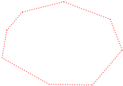
- Extra Points on Line: This setting is used to interpolate extra points along the LINE, POLYLINE, and LWPOLYLINE entities being imported, to increase the number of control points generated.
- Distance Between Points: Click here to enter the map distance between the interpolated points.
In the following example, on the left, the vertices of the imported DXF polyline were imported as-is (no extra points) and displayed as an EZ point map. On the right, extra points were interpolated along the line, in this case every 10 feet.

Step-by-Step Summary
- Access the RockWorks Utilities program tab.
- Create a new, blank datasheet by choosing the File | New | Blank command.
- Select the File | Import | DXF menu option.
- Enter the requested menu settings, described above.
- When you are ready to import the data, click the Process button at the bottom of the window.
The program will read the X, Y, and Z coordinates for the supported entities in the selected DXF file, storing the coordinates in the datasheet in the specified columns.
- Use the Columns | Column Properties menu to assign column names, data types, and units.
See also
 Back to Importing Data

RockWare home page