The next step is to set the print scale.
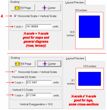
- X = Y? First, choose whether you want the x- (horizontal) and y- (vertical) axes to be scaled equally. If Horizontal Scale = Vertical Scale is checked, then there will be one scale setting to establish. If it is not checked, then you can set the horizontal and vertical scales independently.
The default setting will comply with how the map/diagram was displayed on the screen, though you can certainly make changes at this time.
- For example, if you are printing a map, and the map is plotted on the screen at equal x and y scales (no vertical exaggeration), the default setting in the Print window will be Horizontal Scale = Vertical Scale checked ON.
- If you are printing a cross section, and the section is plotted on the screen at a vertical exaggeration of 10, then the default setting in the Print window will be Horizontal Scale = Vertical Scale checked OFF, and the vertical scale will be 1/10th the horizontal scale.
- Scale Next, you have some scaling choices:
- Specific Scale: If you want a precise output scale, use the Scale prompt to type in a specific scale, in your diagram or map units to be printed per inch or centimeter of paper (output units specified in Step 2).
Examples:
- To plot your map (whose units are in feet) where 1 inch on the paper represents 100 map feet, you would type in: 100 so that the prompt reads "1 inch = 100 units"
- To plot your map (whose units are in meters) where 1 centimeter on the paper represents 500 map meters, you would type in: 500 so that the prompt reads "1 cm = 500 units"
If the wrong paper units are displayed, return to Step 2 (link below) to establish your output units.
If the Horizontal Scale = Vertical Scale setting is off, you can type in specific scale values for both the horizontal (x) and vertical (y) axes of the diagram/map.
- Fill Page: Or, if specific scale is not important, click the Fill Page button to fill the page as much as possible, honoring the current state of the Horizontal Scale = Vertical Scale setting.
- After you complete an edit of the scaling settings, the Layout Preview will update the representation of the diagram (blue) on the output paper.
- Center
Next, click the Center button if you wish to center the map/diagram at the current scale settings. The Layout Preview will be updated.

RockWare home page