![]()
The Raster Image Attributes window is used to define or to modify the location, layer, and appearance for a bitmap-style image in a map or diagram. This window is displayed when you edit an existing image or insert a new image into a map or diagram. These images can include aerial photos displayed over maps, raster logs in striplog views, logos, etc.
Appearance Options
- Plot Border: Insert a check in this box to plot the outer border for the image. Click on the line box to choose the style, thickness, and color for the border lines.
- Clip Image: Insert a check in this box if the image is to be clipped. If activated, you need to define the image pixels to drawn at the edges of the RockPlot rectangle.
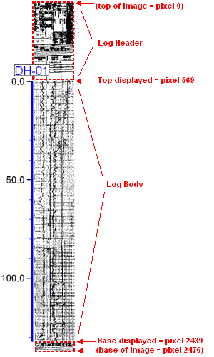
! Raster images store vertical pixels with 0 at the top, and horizontal pixels with 0 along the left. The pixel numbers you define below must be referenced to the 0,0 location at the top, left corner of the image.
- Top: Type in the pixel location to be displayed at the top of the visible image. For example, if you are displaying a raster log, and you want the pixel at the base of the log's header to be displayed at the top of the visible image, you would type in the vertical pixel. In the example below, you would type in 569.
- Bottom: Type in the pixel location to be displayed at the base of the image. In the example above, to display only down to the base of the log body (omitting the footer), you would type in 2439.
- Left: Type in the pixel location to be the left edge of the visible image.
- Right: Type in the pixel location to be the right edge of the visible image.
- Stretch: Insert a check here to stretch the image within the declared coordinate rectangle. If you leave this box un-checked, RockPlot will instead fill the coordinate rectangle as much as possible, while maintaining the image's original aspect ratio.
- Opacity - Choose between defining a specific color to be rendered transparent and assigning a specific opacity percent to the entire image.
- Transparent Color: Choose this option to define a specific color in the raster image that is to be displayed transparent. You can select that color from the drop-down color box; click the Other button for more options or to define a specific color.
! Note that the color selection is very specific - true white (RGB 255 255 255) will not match nearly-white (RGB 251 252 247).- Opacity: Use this setting to adjust the transparency of the entire image. At 100% the image will be fully opaque.
Location Options
- Layer: Use this setting to select the layer to which the image is to be associated. See Working with Layers for more information.
- Corner Points: The position of the image can be defined by editing these coordinates or by interactively moving/resizing the image box.
- West: This coordinate defines the left or western edge for the visible image.
- North: This coordinate defines the upper or north edge for the visible image.
- East: This coordinate defines the right or east edge of the visible image.
- South: This coordinate defines the lower or south edge of the visible image.
General Options
- Visible: Insert a check in this box for the image to be visible in the drawing or map. Remove the check-mark to hide the image.
![]() Back to Editing Tools
Back to Editing Tools
![]()