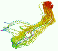
This program is used to import the data from an ModPath ASCII "Pathline File" into the RockWorks datasheet. It offers display of the points as 3D spheres, with other standard 3D layers available as options.
Feature Level: RockWorks Basic and higher
Menu Options
Step-by-Step Summary
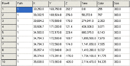
RockWorks will read the input Modpath Pathline file, and it will create a new datasheet that lists path line number; X, Y, and Z coordinates for the measurement; cumulative tracking time, color (automatically assigned, with hot colors = short times and cool colors = long times), and "size".
If you requested a diagram, it will be displayed in a RockPlot3D tab in the Options window, using the requested display type.
The datasheet that is produced by the ModPath import program is depicted within the following diagram:
![]() Back to Importing Data
Back to Importing Data
![]()