Faults | Import | Convert 2D Fault -> 3D Fault
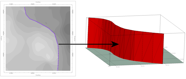
This program reads a 2D fault currently stored in the project Faults table and converts it to a 3D fault, with user-defined elevations.
! The number of faults you can maintain in your project is determined by the feature level of the software:
- Basic: 3 Faults
- Standard: 3 Faults
- Advanced: Unlimited Faults
Menu Options
Step-by-Step Summary
- Fault Name: Click on this tab to select which of the 2D faults in the current project you wish to convert. Choose the name of the Fault to Export using the drop-down list.
If there are no 2D faults present, the program will display a warning as such.
- Attributes: Use these settings to establish general fault and display settings. These will be stored with the fault in the database and can be accessed/edited using the Edit Fault button in the Faults tab.
- Fault Name: Enter the name to assign to the new, converted 3D fault, to distinguish it from other faults. This is displayed in the Name column in the Faults table, and can be displayed as labels on the fault polylines.
- G-Value: Assign a G-Value to the fault. This is assigned to model nodes that intersect the fault triangles.
- Comment: Use this optional field to list any descriptive comments for the fault, for your reference only.
- Line Style: Choose a line color and style with which to represent the fault in 2D maps and sections, and as a polyline in 3D.
- Fill Color: Assign a Fill Color for the fault panels when displayed in 3D.
- Line Symbols: Use these settings to define the symbol style if, during 2D map creation, if you choose to include symbol along the fault polyline.
- Symbol Line Thickness: Click the up/down arrows to assign a thickness for the lines which will make up the fault symbols. "1" will generate thin lines, "3" relatively thick lines.
- Type of Symbol: Choose a symbol type from the drop-down list. If you choose a Custom type, click to the right to select the custom symbol design.
- Elevations: Use these settings to define the upper and lower extents of the new 3D fault.
- Minimum Value: Enter the minimum elevation for the fault.
- Maximum Value: Enter the maximum elevation for the fault.
- Access the Faults program tab.
- Select the Faults | Import | Convert 2D Fault -> 3D Fault menu option.
- Enter the requested menu settings, described above.
- Click the Continue button to proceed.
RockWorks will read the location of the 2D fault and create a new 3D fault at the same location, extending between the elevations you defined. The new fault will be stored in the Faults table in the project database.
- You can now use this fault, along with other enabled faults in the Fault table, when creating a surface model or solid model and applying faulting.
 Back to Faults Program Tab

RockWare home page