These files are used to build a 3D image containing tubes or pipes drawn between pairs of user-specified XYZ points. The program requires 9 columns of information: The names for the individual tubes, the tube color, and the X, Y, and Z coordinates for the beginning and ending points of the tubes, and the radius of each tube.
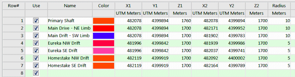
- Name: Optional. These will simply be used to label the pipes in the data tree within RockPlot3D.
- Color: Required. This determines the color in which the pipes will be plotted.
- X1, Y1, Z1: Required. These assign easting, northing and elevation coordinates for one end of each pipe. Be sure to assign the coordinate system and units to the columns.
- X2, Y2, Z2: Required. These assign easting, northing, and elevation coordinates for the other end of each pipe.
- Radius: Required. This defines the radius for the tubes, in feet or meters.

RockWare home page