These RockWorks data files identify locations using 2 or more sightings in bearing and inclination to known control points. These can be translated to XYZ coordinates using the Utilities | Survey | Triangulation program.
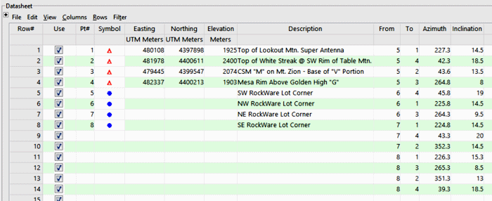
- Control Points: For stations to be used as control points, these columns are required. There must be at least two control points declared in the datasheet in order for the program to compute survey station locations.
- Control point number: You must declare a station number for each control point in the listing. The program will use these numbers to identify each point.
- X-coordinate: Declares the X-coordinate or Easting for the control point. Be sure to define your coordinate system and units for the location coordinates and elevations.
- Y-coordinate: Declares the Y-coordinate or Northing for the control point.
- Elevation: Declares the Z-coordinate or elevation for the control point.
- Description (optional): Declares any descriptions for the control point.
- Survey Stations: For survey stations whose XYZ coordinates are not known and are to be computed by the program, the datasheet columns must contain these measurements:
- From, To: Enter the numbers of the starting and ending control points for which the following measurements are defined. Be sure you have defined the known Easting and Northing coordinates and elevations for all, as described above.
- Azimuth: Enter the 0-360 degree bearing from the "From" point to the "To" point.
- Inclination: Enter the inclination in degrees, measured between the From and To points. 0= horizontal, with positive degrees above horizontal, and negative degrees below horizontal.
- Description: (Optional) Declares any descriptions for the survey station. There is a limit to 60 characters for this field.
If there are survey stations that reference undeclared control points, the program will be unable to compute their XYZ coordinates.
- Triangulation_Survey_01.rwDat

RockWare home page