These files are used to build a 3D stratigraphic fences, models, and stacked surfaces from existing grid models. They are used in the RockWorks | Borehole Operations | Stratigraphy | Grids -> 3D Strat Diagram, 3D Exploded Stratigraphy, and 3D Stratigraphic Quadrants programs.
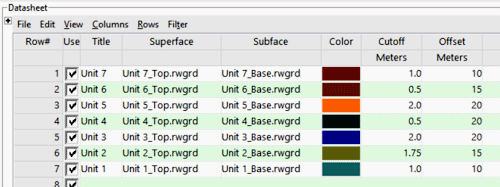
- Title: Required. This is the name that will appear within the RockPlot3D data "tree" (the list of items along the side of the screen). This allows the user to "peel" off individual formations when viewing the output.
- Superface: Required. Grid model that represents the top of a given unit. Be sure the .RwGrd file resides in the current project folder.
- Subface: Required. Grid model that represents the base of a given unit. Be sure the .RwGrd file resides in the current project folder. You need to list the grid models of both the upper and lower surfaces so that the program can compute unit thickness.
- Color: Required. Color to be used when rendering the unit.
- Cutoff: Optional. This value represents the minimum thickness. Portions of a unit whose thickness is below this setting will be rendered 100% transparent. The unit’s thickness is computed by subtracting the subface elevations from the superface elevations. This setting is used to allow for erosion of very thin layers, but is used only in building Stratigraphic Models (not fences or stacked surfaces).
Be sure to define the units for this measured distance - see Defining your Datasheet Coordinates and Units for information.
- Offset: Optional: This value represents the vertical offset, if any, for the unit, should you wish to "explode" the view when displayed in 3D. The value is expressed in your vertical (Z) units. A positive value will offset the surfaces upward, and a negative value will offset them downward. The offsets can be different for each unit. As above, be sure to define the units for this measured distance.
! When creating the list of units, be sure to list them in reverse order (with the lowest stratigraphic unit at the top of the listing to highest stratigraphic unit at the bottom of the listing). This convention is due to a restriction within the OpenGL environment.
! ! All of the .RwGrd models must have the same dimensions and node spacing in order for the program to be able to build the stratigraphic diagrams.
- Strat_Grids_to_Model.RwDat

RockWare home page