Well drawdown data can be entered into the RockWorks Datasheet for the purpose of computing and displaying a drawdown surface (Hydrology | Drawdown Surface). Specific fields are required.
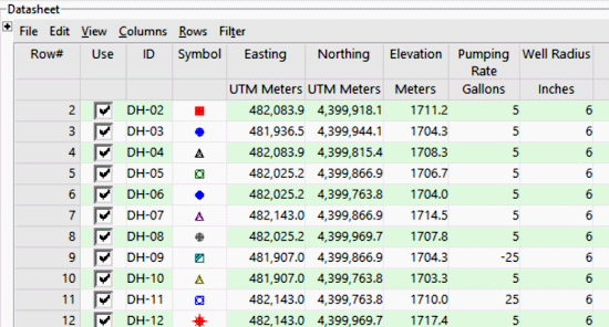
Example 1 - Simplified (Single Thickness and Transmissivity)
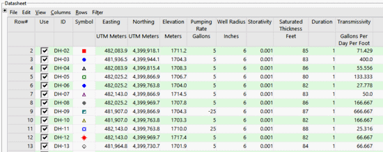
Example 2 - Isotropic (Single Transmissivity)
Example 3 - Anisotropic (Separate X and Y Transmissivities)
Column Summary
- ID: Optional.
- Symbol & Color: Optional. Handy if you wish to create point maps showing well locations.
- X (Easting), Y (Northing) Coordinates: Required. RockWorks must have location information in order to compute the drawdown surface. The location coordinates may represent a local coordinate system, or a global coordinate system such as UTM or longitude/latitude. See Defining your Datasheet Coordinates and Units for information.
- Elevation: Required. Here you must list the pre-pumping elevation for the water level, so that the program can deliver true elevations as output. Be sure to define the units (feet or meters), as explained with the link above.
- Pumping rate: Required. Units need to be defined in gallons or liters per minute. If the well is an injection well, the rate can be entered as a negative value.
- Well radius: Required. Units need to be defined.
Sample file
- Hydrology_Drawdown_Constant.rwdat
Column Summary
- ID: Optional.
- Symbol & Color: Optional. Handy if you wish to create point maps showing well locations.
- X (Easting), Y (Northing) Coordinates: Required. RockWorks must have location information in order to compute the drawdown surface. The location coordinates may represent a local coordinate system, or a global coordinate system such as UTM or longitude/latitude. See Defining your Datasheet Coordinates and Units for information.
- Elevation: Required. Here you must list the pre-pumping elevation for the water level, so that the program can deliver true elevations as output. Be sure to define the units (feet or meters), as explained with the link above.
- Pumping rate: Required. Units need to be defined in gallons or liters per minute. If the well is an injection well, the rate can be entered as a negative value.
- Well radius: Required. Units need to be defined.
- Storativity: Required. This has no units.
- Saturated thickness: Required. Units need to be defined.
- Duration: Required. Note that the program assumes here that the units represent days.
- Transmissivity: Required. Units in gallons per day per foot (Imperial units) or square meters (metric units).
Sample file
- Hydrology_Drawdown_Isotropic.rwdat
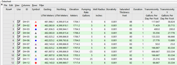
Column Summary
- ID: Optional.
- Symbol & Color: Optional. Handy if you wish to create point maps showing well locations.
- X (Easting), Y (Northing) Coordinates: Required. RockWorks must have location information in order to compute the drawdown surface. The location coordinates may represent a local coordinate system, or a global coordinate system such as UTM or longitude/latitude. See Defining your Datasheet Coordinates and Units for information.
- Elevation: Required. Here you must list the pre-pumping elevation for the water level, so that the program can deliver true elevations as output. Be sure to define the units (feet or meters), as explained with the link above.
- Pumping rate: Required. Units need to be defined in gallons or liters per minute. If the well is an injection well, the rate can be entered as a negative value.
- Well radius: Required. Units need to be defined.
- Storativity: Required. This has no units.
- Saturated thickness: Required. Units need to be defined.
- Duration: Required. Note that the program assumes here that the units represent days.
- Transmissivity X: Required. Units need to be identified (gallons per day per foot or square meters).
- Transmissivity Y: Required. Units need to be identified (gallons per day per foot or square meters).
Sample file
- Hydrology_Drawdown_Anisotropic.rwdat
![]()