RockWorks | Borehole Manager | File | Export | Aquifers
This program will export to a variety of formats (RwDat, CSV (Excel), Text, RTF, and Shape) the borehole ID, XY coordinates, and the depth or elevation or thickness of a selected Aquifer for selected boreholes for selected date(s). This can be used to verify data stored in the database, or to model the data in another program.
Menu Options
Step-by-Step Summary
- Spatial Filter: Insert a check in this box at the top of the program window to activate a data filter based on spatial coordinates. Click this button to enter the filter settings. Click the Return to Previous Menu button when you are done entering the filter settings. (More info)
- Time Filter: Insert a check in this box at the top of the program window to filter the data based on date/time. Click this button to enter the filter settings. If you leave this un-checked the program will output all of the measurements, for all listed dates. Click the Return to Previous Menu button when you are done entering the filter settings. (More info.)
- Aquifer Track: Click here to select which aquifer is to be exported.
- Column Data type: Click to select the desired Z3 value in the exported file (Thickness or Mid-Point).
- Output Options
Click this tab to define the output format(s) for the exported data. You can select multiple options.
- RwDat (RockWorks): Check this option for the Aquifer data to be exported to a RockWorks datasheet (.RwDat) format. (More info)
- CSV (Excel): Check this option for the Aquifer data to be exported to a CSV file format for use in Excel. (More info)
- TXT (Notepad): Check this option for the Aquifer data to be exported to a text (.txt) format. (More info)
- RTF (Word): Check this option for the Aquifer data to be exported to an RTF file format for use in Word. (More info)
- SHP (ArcMap): Check this option for the Aquifer data to be exported to a Shapefile format. Click on this tab to set up the options.
- Output (Shape) File:: Click to the right to type in a name to assign the Shapefile to be created. The exporter will also create the accompanying .SHX and .DBF files.
- Null Value: If any of your borehole Aquifer data are missing the depth to top or base for the interval, RockWorks will store a null value for that depth. Use this prompt to define the null value to be used, such as "-999".
- Output Type
- Polylines: Choose this output style if you wish to see the data as polylines.
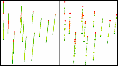
- Points (midpoint): Choose this output style to see the data as points. Compare the images below; the left image represents lithology data displayed as polylines in ArcScene. The right image represents lithology midpoints (on top of lithology polylines for reference).
-
- Access the RockWorks Borehole Manager program tab.
- Be sure there is aquifer data listed for one or more boreholes.
- Be sure the boreholes to be processed (if more than one) are shown as Enabled in the borehole listing.
- Select the File | Export | Aquifers menu option.
- Enter the requested menu settings, discussed above.
- Click the Continue button to proceed.
The program will extract the selected data from the database, and record the borehole ID, XY coordinates, and requested Z value (depth, elevation, thickness) in the requested output file(s).
 Back to Export Data

RockWare home page