 Estimated time: 3 minutes.
In this lesson, you will add to the view an existing 3D scene that contains a solid model "isosurface" and a floating aerial image.
- Before continuing, be sure you have completed at least the first two lessons (plot logs and append stratigraphy). Or, if you are rejoining this tutorial after a break, look for the RockPlot3D file rp3dt_logs+strat.Rw3D in the Project Manager pane. Double-click on it to open this view.
- Append the solid model:
- With the logs and surfaces still displayed in the image pane, click on the RockPlot3D File menu and click on the Append option.
- Locate the existing solid model image named rp3dt_benzene.Rw3D and click on that file name. Click the Open button to open that file. (This file should reside in the "My Documents\Rockworks17 Data\Samples" folder.
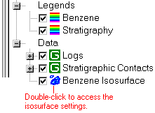
- You will see a block now displayed in the image pane, and a new data item "Benzene Isosurface" in the data pane.
- You will also see an aerial photo above the surfaces, an "Aerial Photo" item in the data listing, and the actual image file name, "1955_Airphoto.png," displayed in the Linked File List to the lower-right.
- Double-click on the Benzene Isosurface item in the data pane. The program will display the Isosurface Options window.
- Adjust the isosurface filter.
- Locate the Iso-Level section in the middle of the window. The defaults show the minimum (left) and maximum (right) values stored in the solid model. The current iso-level value should be set to 30.
- Into the Iso-Level Value prompt, type in: 5 and click the Apply button. This tells the program to display those areas in the solid model with benzene concentrations greater than or equal to 5. You should see the image has changed, displaying a much larger isosurface.
- Now type 50 into the isolevel prompt, and click Apply. Now you'll see a much smaller area with such high concentrations.
- Remove the check-mark from the Logs group and/or the Stratigraphic Contacts group and/or the floating image in the data pane, to see the isosurface more clearly. Or, you can expand either of those groups to selectively remove logs and/or surfaces.
- Rotate
 the image to see different views.
- Use the Zoom In tool
 to click-and-drag an enlargement rectangle, to see a bigger view. You can rotate and pan the image while zoomed in.
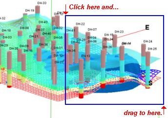
- Zoom back out just by clicking the Zoom Out button.
- Save the current view:
- Select the File | Save As command.
- In the File Name prompt, type in: rp3dt_logs+strat+solid and click the Save button.
RockPlot3D will store this new, combined image under this new name, with an ".Rw3D" file name extension.
 RockPlot3D Isosurface Settings
See also: Borehole Manager tutorial for many lessons on generating the 3D isosurfaces.
 Back to RockPlot3D menu | Next (export & zip)

RockWare home page