RockWorks | Utilities | Grid | Grids -> Stratigraphic Model
This program creates a 3D stratigraphic model diagram based on a list of existing grid models that represent the top ("superface") and base ("subface") of each unit. These are grid models that must already exist on your computer.
This program is designed for two types of applications:
- Users who have created their grid models within other applications (e.g. ModFlow, Surfer) and wish to use RockWorks to create stratigraphic (or hydrostratigraphic) diagrams.
- Users who have created their grid models within the Borehole Manager portion of RockWorks but need more flexibility in dealing with stratigraphic relationships (e.g. special manipulations with the grids).
This is a "manual" way of creating the kind of stratigraphic model that's available in the Borehole Manager's Stratigraphy | Model tool.
Menu Options
Step-by-Step Summary
Menu Options
- Specify the Input Column information in the left pane of the window:
- Title: Select the name of the column in the datasheet that lists the formation title as it will be displayed in RockPlot3D.
- Superface: Select the name of the column in the datasheet that lists the names of the grid files (.RwGrd) that represent each unit’s upper surface.
- Subface: Select the name of the column in the datasheet that lists the name of the grid files (.RwGrd) that represent each unit’s lower surface.
- Color: Select the name of the column in the datasheet that displays the color in which the unit is to be represented in the stratigraphic fence.
- Cutoff: Select the name of the column in the datasheet in which each unit’s minimum thickness values are listed. During the building of the model, any units whose thickness values fall below the declared cutoff will be set to transparent. This is a means of eroding thin units.
- Offset: Select the name of the column in the datasheet, if any, in which the unit's vertical offset from the next layer down is defined. This is a means of "exploding" surfaces in the 3D view for easier visualization. (See Explode below.)
- Explode: Insert a check here to add vertical offset to each unit, for an "exploded" display in the 3D window. Expand this heading to define how the offset is to work.
- Uniform Spacing: Click in this radio button to define a constant offset spacing between each unit. Expand this heading to type in the offset in your vertical units. A positive value will offset all units upward and a negative value will offset them downward.
- Variable Spacing: Click in this radio button if you have declared specific offsets in the data file and have selected that column under the Offset prompt above.
- Reference Cage: Insert a check here to include in the diagram a 3D frame with coordinates and elevation labels. (More.)
- Stratigraphy Legend: Insert a check in this item to include a legend that lists all of the formation names and their colors and patterns. The program will assume that there is a populated Stratigraphy Types table in the project database. Expand this item to set the legend width, size, and offset. (More.)
Step-by-Step Summary
This program requires that two or more RockWorks-format grid models already exist.
- Access the RockWorks Utilities program tab.
- Open or create a "gridlist" data file that lists the names of the grid models (.RwGrd) representing the upper and lower surfaces of each unit, the titles for the units, and their color. The units should be listed with the lowest unit first, and the highest unit last.
- If you want to include a legend to the stratigraphic names, be sure the formations are listed in the current project's Stratigraphy Types table.
- Select the Grid | Grids -> Stratigraphic Model menu option.
- Enter the requested menu settings, described above.
- Click the Process button to continue.
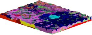
The program will compute the thickness for each unit by subtracting the base grid from the top grid, and will determine if any areas fall below the declared thickness cutoff. The program will then build a 3D stratigraphic model from the bottom up, using the indicated grid models. The completed diagram will be displayed in a RockPlot3D tab in the Options window.
- You can adjust any of the settings in the Options pane and click the Process button again to regenerate the diagram.
! Each time you click the Process button, the existing display will be replaced.
- View / save / manipulate / print / export the image in the RockPlot3D window.
 Back to Grid Menu Summary

RockWare home page