RockWorks | Utilities | Grafix | 2D Utilities | Append
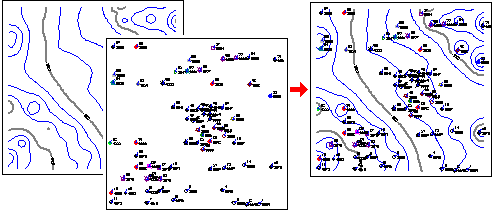
This program is used to combine the contents of two RockPlot2D files (*.Rw2D) for display as a new, combined image. This is a handy way to combine, for example, project contours with a reference base map.
This is the same process as the RockPlot2D | File | Append tool, but is available to RCL command scripts.
Tips on Appending Files
- One of the most important concepts in combining 2D plot files is that the two maps or diagrams must occupy the same coordinates in space in order for them to overlay correctly. Some examples:
- You can overlay a RockWorks point map of a data set with a contour map created of the same data set since they have the same x and y coordinate range.
- You cannot overlay a map of Oklahoma onto a map of Maine since their real world coordinates don't coincide.
- You cannot overlay a point map of Colorado cities that is in longitude and latitude coordinates onto a contour map of Colorado that is in UTM coordinates - again, the coordinates don't coincide.
- You can use the coordinate display in the RockPlot2D toolbar to get an idea of the coordinate range of any diagram. Just move the mouse pointer around the RockPlot2D window and note the change in the coordinate listing.
- You can use the RockPlot2D | Utilities | Rescale command to rescale a map to a different coordinate range.
- You can use the RockPlot2D | Utilities | Convert Map Coordinates to reproject a map to a different coordinate system.
Menu Options
- Primary File: Click on this item to browse for the first existing Rw2D file, onto which the second file is to be appended.
- Secondary File: Click here to select the name of the existing Rw2D plot file that is to be added on top of the above image.
Step-by-Step Summary
Follow these steps to combine two RockPlot2D images using the Grafix menu tool:
- Be sure the two files you wish to combine reside in the current project folder. These must be "Rw2D" files that were created in RockWorks16 or RockWorks17, or opened from a previous version of RockWorks and updated to the new format.
- Access the RockWorks Utilities program tab.
- Select the Grafix | 2D Utilities | Append menu option.
- Enter the menu items as described above.
- Click the Process button to continue.
The program will read the contents of the "primary" Rw2D file and will append to it the contents of the second file you specified above. The combined files will be displayed in a RockPlot2D tab in the Options window.
- View / save / manipulate / print / export the map in the RockPlot2D window. (More.)
- Note that since the Options window remains open, you can repeat this process for additional files by selecting new Rw2D file names and clicking the Process button to combine them.
! Each time you click the Process button, the existing display will be replaced, so be sure to save any combined images you wish to retain before re-processing.
More Tips
- Adjust the stacking order of the images in RockPlot2D by right-clicking on the layer name or on the item itself and selecting Bring to Front or Send to Back.
- Adjust the transparency of raster images or color-filled contour layers by right-clicking on them and adjusting the Opacity setting.
See also
- The Montage tool for information about rescaling and combining plots.
 Back to Grafix Menu Summary

RockWare home page