RockWorks | Utilities | EarthApps | Points | Quick Locator
This program:
- Reads a single XY coordinate pair that you type into the program prompt. The point can represent any supported coordinate system.
- Creates a KML output file with this point location.
- Creates a KMZ (zip) output file, containing the KML file.
- Loads the KMZ file in Google Earth, if requested.
See also: Icon Maps - Simple for plotting multiple points.
Menu Options
Step-by-Step Summary
Menu Options
- Lon/Lat: Click this tab if the coordinates you wish to map in Google Earth represent longitude and latitude coordinates.
- Longitude: Enter the longitude coordinate for the point to be mapped. Note that western longitudes must be entered as negative values.
- Latitude: Type into this prompt the latitude coordinate for the point to be mapped. Southern latitudes must be entered as negative values.
- Decimal Degrees: Click in this button if the coordinates are entered as decimal degrees, such as:
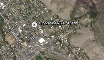
-105.209817 and 39.748455
- Degrees & Decimal Minutes: Click in this button if the coordinates are entered as integer degrees and decimal minutes, such as:
-105°12.589' and 39°44.907'
- Degrees, Minutes, and Seconds: Click in this button if the coordinates are entered as integer degrees and minutes, and decimal seconds, such as: -105°13'0.0" and 39°45'0.0"
- Local: Click this tab if the point to be mapped will be entered as local coordinates with a longitude and latitude reference point.
- Easting: Enter here the X coordinate of the point to be mapped.
- Northing: Enter the Y coordinate of the point to be mapped.
- Units: Choose whether these coordinates represent feet or meters.
- Local Coordinate System Origin: In order for these local coordinates to be referenced to the globe, you need to enter the longitude and latitude coordinates which are represented by the local system origin (0,0).
- Longitude: Type in the decimal longitude for the local origin. Be sure that western longitudes are negative.
- Latitude: Type in the decimal latitude for the local origin. Southern latitudes must be negative.
- PLSS: Click this tab if the point to be displayed in Google Earth will be entered using Public Land Survey System descriptions.
! To map this type of coordinate, you need to be sure you've downloaded the RockWare LandBase first. See the LandBase topic for details.
- Meridian: Click on this button to select the meridian from the displayed map by clicking in the radio button.
- Range: Type in the Range number and select West or East from the drop-down list.
- Township: Enter the Township number and select South or North from the drop-down list.
- Section: Type in the Section number.
- Description: RockWorks support two different means of defining points within the specified Range, Township, and Section.
- Offset: Click on this option to enter the location as an offset from the section boundaries. Type in the offset distances in feet, and select the appropriate edge: FEL = feet from the East line; FNL = feet from the North line; FSL = feet from the South line; FNL = feet from the North line.
- Quarter: Click on this option to enter the description in a quarter/quarter format. You can enter this a variety of ways:
"NW" or "SW", "SE/SE" or "W2/SE", "SE SE" or "W2 SE", "SE-SE" or "WW-SE", "SESE or "W2SE", "SE,SE" or "W2,SE", or similar. Use upper- or lower-case characters. You may use slash (/) characters, spaces, dashes, or commas within the description. You may also concatenate the descriptions (SESE).
Step-by-Step Summary
- Access the Utilities program tab.
- Select the RockWorks | Utilities | EarthApps | Points | Quick Locator menu option.
- Enter the X and Y coordinate for the point you wish to place in Google Earth, as described above.
- Click the Process button to continue.
The program will create a KML file with the specified map location as a placemark. It will create a KMZ file that contains the KML file. The Google Earth KML and KMZ file names will be assigned automatically.
- If RockWorks displays the KMZ name in a popup window for your reference, you can confirm:
- Automatically load file into Google Earth: Be sure this is checked if you want to display the output at this time.
- Show this message every time a KMZ File is Created: If checked, this window will be displayed each time a Google Earth output is created. Uncheck this if you prefer not to see this window in the future.
(Both of these settings are also available via the Preferences menu.)
- Click OK to continue or Cancel to cancel the operation.
The resulting placemark will be displayed in Google Earth, if requested.
 Back to Point Map Summary
"Google" is a trademark of Google Inc.

RockWare home page