
RockWorks | Utilities | EarthApps | Lines | Parabolas Menu
Use the programs in the Utilities | EarthApps | Lines | Parabolas menu to plot one or more 3D parabolic "polylines" in Google Earth.
Arrows: The parabolas are drawn as segmented 3D arrows, between two geographic locations (X1Y1, X2Y2) read from the datasheet editor.
Lines: The parabolas are drawn as continuous polylines, between two geographic locations (X1Y1, X2Y2) read from the datasheet editor.
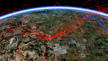
Tubes: The parabolas are drawn as continuous tubes, between two geographic locations (X1Y1, X2Y2) read from the datasheet editor.

![]() Back to EarthApps Summary
Back to EarthApps Summary
"Google" is a trademark of Google Inc.
![]()