RockWorks | Utilities | Coords | Local Origin Lon/Lat
This program is used to compute the "origin" longitude and latitude for a local coordinate system, given a known calibration point. This information can be used to geo-reference a project which uses local coordinates, for output to Google Earth or other GIS program.
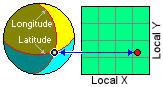
Example: Let's say your local gas-station project coordinates are defined simply by local feet from a property corner, but you want to display your output maps and graphics in Google Earth. Solution: You can use this program to enter a known longitude and latitude coordinate for a specific local point, compute the longitude and latitude coordinate for the local system origin (0,0), and enter that origin lon/lat into your RockWorks database or datasheet.
- Input: Calibration Point
- Local Coordinates
- Easting: Enter the X coordinate for a known point in your local coordinate system.
- Northing: Enter the Y coordinate for the known point.
- Units: Choose whether these known local coordinates represent feet or meters.
- Global Coordinates
- Longitude: Type in the decimal longitude coordinate at the above reference point. A western longitudes needs to be entered as a negative value.
- Latitude: Type in the latitude coordinate at the above reference point. A southern latitude needs to be entered as a negative value.
- Show location in Google Earth: Click this button if you want to display your reference coordinate as a point in Google Earth.
- Select the Utilities | Coords | Local Origin Lon/Lat menu option.
- Enter the input local and global coordinates as described above.
- Click the upper Show Location in Google Earth button if you want to see the reference point location displayed in Google Earth.
- To compute the system origin coordinate, click the Compute button at the bottom of the window.
RockWorks will calculate the longitude and latitude at the 0,0 point in your local coordinate system and display these in the output prompts.
- Click the lower Show Location in Google Earth button to display the calculated origin location in Google Earth.
- Click the Copy to Windows Clipboard button to copy the computed origin coordinates to the clipboard for pasting into the Borehole Manager database, a RockWorks datasheet, or the project coordinates tab.
 Back to Coords Menu Summary

RockWare home page