Use the Spatial Filtering Options tab to activate a data filter based on X, Y, and/or Z coordinate ranges. You can also use D to specify a depth range. You can enter data ranges for any or all of the following variables by inserting a check in the appropriate box(es) and defining the coordinate minimum and maximum. The program will ignore data that lies outside the declared range(s), omitting that data from processing.
- X (Easting) Filter: Check this item to limit processing to data points within a specific east-west range. If activated, use the prompts to enter the minimum and maximum X coordinates in your project data to be included in the logs or modeling process.
- Y (Northing) Filter: Check this box to limit processing to data points within a specific north-south range. Use the prompts to enter the minimum and maximum Y coordinates to be included in the logs or modeling process.
- Z (Elevation) Filter: Check this item to limit processing to data points within a specific elevation range. Use the prompts to enter the minimum and maximum elevations.
- D (Depth) Filter: Check this box to limit processing to data points within a specific depth range. Use the prompts to enter the minimum and maximum elevations.
-
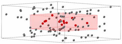
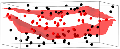
- Upper Surface: Activate this setting to have RockWorks ignore data that is above a designated surface (grid model).
- Grid File: Click on this button to browse for the name of the existing RockWorks grid model (.RwGrd file) to use to constrain the data; any data points above the surface will not be processed for your log, diagram, model, etc.
- Lower Surface: Activate this setting to have RockWorks ignore data that is below a designated surface (grid model).
- Grid File: Click on this button to browse for the name of the existing RockWorks grid model (.RwGrd file) to use to constrain the data; any data points below the surface will not be processed.
! Note that these Upper- and Lower-filters are DATA filters. There is a separate post-modeling filter that constrains solid models.
- Polygon: Check this box to ignore data that lies either inside or outside a defined polygon area.
- Polygon Table: Click on this button to select the name of the Polygon Table containing the coordinates to use for the filter.
- Include Points Inside: Choose this if you wish to include the points inside the polygon, ignoring those outside.
- Include Points Outside: Choose this if you wish to include the points outside the polygon, ignoring those inside.
 Back to Rules and Filters

RockWare home page