RockPlot2D | File | Open
The RockPlot2D program can be used to open an existing 2-dimensional RockWorks graphic file, such as a map, cross section, or chart/diagram, that has been saved as a RockWorks ".Rw2D" file. (See Opening RockPlot2D Images.)
If you have graphics created from earlier versions of RockWorks ("RK6" created by RockWorks2006 - RockWorks15, and "RKW" files created by RockWorks2002 - RockWorks2004), you can open these as well.
Step-by-Step Summary
- If there is no RockPlot2D window yet displayed on the screen, you will need to create a new RockPlot2D window first.
- Select the File | Open menu command.
- In the displayed dialog box, select the older file type (RK6, RKW) using the drop-down list in the lower-right corner.
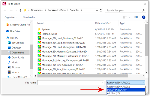
- Browse for the file you wish to open, accessing other drives or directories as necessary.
- When you have selected the file, click the Open button.
- RockPlot will now prompt you to re-save the file in the current project folder, using the newer Rw2D format. Type in a name for the new file.
- Now, you need to tell RockPlot what kind of image this is.
- Choose None if you don't know (or don't particularly care) what kind of image this is. This just tells RockPlot that there is no need to geo-reference the image.
- Choose Map if this is a plan-view map image.
Next you'll be prompted to tell the program whether your XY coordinates (your map units) were.
- Choose Undefined if you don't know what the original units represented or if you don't wish to georeference this image.
- Choose from the other coordinate systems if you would like to geo-reference this image, for output to Google Earth or other software.
- Choose Section or Profile if this is a cross-section view.
As above, you'll be prompted to tell the program whether your XY coordinates (your map units) were.
- Choose Undefined if you don't know what the original units represented or if you don't wish to georeference this image.
- Choose from the other coordinate systems if you would like to geo-reference this image, for output to Google Earth or other software.
- Choose Chart if this is a generic diagram, such as a stereonet or frequency histogram - which has no coordinate reference.
- You can click on the Coordinate Summary tab to see the horizontal and vertical diagram extents.
- Click OK when you're ready to open the file.
- The program will update the image to the new graphic format, append the geographic "meta-data", and load the graphic file into the RockPlot2D window.
 Back to Managing RockPlot2D Files

RockWare home page