RockPlot2D | Utilities | Clip
This program is used to extract from an existing map or diagram all of the contents that lie within a user-declared rectangular area. The clipped image is displayed in a new, untitled RockPlot2D window.
The clip region is defined either:
- Within a program dialog box (Utilities | Clip)
- Interactively, with a mouse (Utilities | Clip with mouse). This tool is also available using the Clip button
 in the left-hand toolbar.
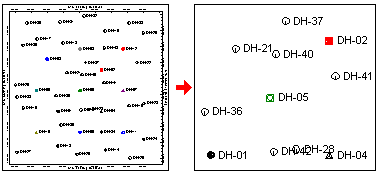
This can be used, for example, to illustrate portions of a regional map that lie within your study area or lease. Or, it can be used to clip only particular portions of a diagram for export.
Follow these steps to display a rectangular subset of an existing 2D plot in a new RockPlot2D window.
- If necessary, open the diagram to be clipped (see Opening Plot Files) or click in the current RockPlot2D window containing that diagram.
- Choose either of the following clipping methods:
- Select the RockPlot2D Utilities | Clip menu command. The program will display a dialog box showing the existing boundary coordinates of the current map.
- For each axis, enter the coordinate that is to become the new boundary for the diagram. (You may leave any of the boundaries as-is if they are not to be clipped.) All diagram entities that lie outside the coordinates you enter will be removed from the clipped diagram.
- When the new coordinate(s) are entered to your satisfaction, click on the OK button.
- Or, click on the Clip button in the toolbar to the left.
- Position the mouse cursor on the upper-left corner of the area to be extracted, and click and hold the mouse button.
- Holding the mouse button down, drag down and to the right until the cursor is placed at the lower-right corner of the area to be extracted. (As you drag you'll see a rectangular "rubber-band" around the selected area.)
- Release the mouse button when the area to be clipped is selected.
- The program will determine which items within the plot file lie within the specified coordinates and display these in the plot window.
- You can use the File menu commands to save or print the map or diagram, to combine the file with another graphic file, or to exit RockPlot2D.
- RockPlot2D’s Digitizing Tools for information about digitizing coordinates on the screen
 Back to Manipulating RockPlot2D Files

RockWare home page