The Borehole Manager contains several export tools used to organize the different data types of all of the boreholes in a manageable and transportable way. This section discusses the output layout of the exported data blocks or files (ASCII export) or spreadsheets (Excel export) that result from the Borehole Manager | File | Export | Multiple Tables | Text or Excel functions.
- Borehole Data
- Accessory information
Exported Location Data
Using the Borehole Manager’s Export tools, the program will list the borehole location information (from the Location table) in columns in the following order:
- Column 1: Borehole name (the borehole name on the Location tab). This will be the "index" for all of the other data fields.
- Column 2: Borehole status (enabled or disabled)
- Column 3: Symbol
- Column 4: Symbol color
- Column 5: Google Earth icon number
- Column 6: Easting
- Column 7: Northing
- Column 8: Elevation
- Column 9: Collar elevation
- Column 10: Total depth
- Columns 11 - 24: Other coordinate fields
- Columns 25+: Optional coordinate fields
Notes:
- Symbol color is represented in integer format. See Color Numbers, below for some sample color/integer associations.
- Additional, customized fields will be listed to the right of the standard columns.
- In the text export, this block is flagged with the <LOCATIONS> and </LOCATIONS> tags.
Back to top
Exported Orientation Data
Using the Borehole Manager’s Export tools, the program will list the borehole downhole survey information (from the Orientation table) in columns in the following order:
- Column 1: Borehole name
- Column 2: Depth at which survey data was taken
- Column 3: Bearing of borehole (0 to 360)
- Column 4: Inclination of borehole (-90 = straight down, 0 = horizontal, 90 = straight up)
Notes:
- Each survey listing for each borehole will occupy a separate row in the output file.
- In the text export, this block is flagged with the <ORIENTATION> and </ORIENTATION> tags.
Back to top
Exported Lithology Data
Using the Borehole Manager’s Export tools, the program will list the borehole lithology data (from the Lithology table) in columns in the following order:
- Column 1: Borehole name
- Columns 2 and 3: Depths to the top and base of the lithologic interval
- Column 4: Lithology keyword
- Column 5: Comments
- Columns 6 – 8: If requested, these columns will list the computed X, Y, and Z (elevation) coordinate at the top of the interval, accounting for any downhole survey information.
- Columns 9 - 11: If requested, these columns will list the computed X, Y, and Z (elevation) coordinates at the base of the interval, accounting for any downhole survey information.
Notes:
- Each lithology interval for each borehole will occupy a separate row in the output file.
- In the text export, this block is flagged with the <LITHOLOGY> and </LITHOLOGY> tags.
Back to top
Exported Stratigraphy Data
Using the Borehole Manager’s Export tools, the program will list the borehole stratigraphy data (from the Stratigraphy table) in columns in the following order:
- Column 1: Borehole name
- Columns 2 and 3: Depths to the top and base of the formation
- Column 4: Formation name
- Column 5: Comments
- Columns 6 - 8: If requested, these columns will list the computed X, Y, and Z (elevation) coordinate at the top of the formation, accounting for any downhole survey information.
- Columns 9 - 11: If requested, these columns will list the computed X, Y, and Z (elevation) coordinates at the base of the formation, accounting for any downhole survey information.
Notes:
- Each stratigraphy interval for each borehole will occupy a separate row in the output file.
- In the text export, this block is flagged with the <STRATIGRAPHY> and </STRATIGRAPHY> tags.
Back to top
Exported Well Construction Data
Using the Borehole Manager’s Export tools, the program will list the borehole well construction data (from the Well Construction table) in columns in the following order:
- Column 1: Borehole name
- Column 2: Outer Diameter for the material type
- Column 3: Inner Diameter for the material type
- Column 4: Offset
- Columns 5 and 6: Depths to the top and base of the material interval
- Column 7: Material name
- Column 8: Comments
- Columns 9 - 11: If requested, these columns will list the computed X, Y, and Z (elevation) coordinate at the top of the material interval, accounting for any downhole survey information.
- Columns 12 - 14: If requested, these columns will list the computed X, Y, and Z (elevation) coordinates at the base of the interval, accounting for any downhole survey information.
Notes:
- Each well construction interval for each borehole will occupy a separate row in the output file.
- In the text export, this block is flagged with the <WELLCONSTRUCTION> and </WELLCONSTRUCTION> tags.
Back to top
Exported I-Data
Using the Borehole Manager’s Export tools, the program will list the borehole interval data (from the I-Data table) in columns in the following order:
- Column 1: Borehole name
- Column 2: The measurement type, corresponding to the I-Data column name (such as "Benzene")
- Columns 3 and 4: Depths to the top and base of the sampled interval
- Column 5: The listed value for that component, for that interval, for that borehole
- Columns 6 – 8: If requested, the computed X, Y, and Z (elevation) coordinate at the top of the interval, accounting for any downhole survey information.
- Columns 9 – 11: If requested, the computed X, Y, and Z (elevation) coordinates at the base of the interval, accounting for any downhole survey information.
Notes:
- Each I-Data measurement for each borehole will occupy a separate row in the output file.
- In the text export, this block is flagged with the <INTERVAL> and </INTERVAL> tags.
Back to top
Exported I-Text
Using the Borehole Manager’s Export tools, the program will list the borehole Interval-Text data (from the I-Text table) in columns in the following order:
- Column 1: Borehole name
- Column 2: The name of the I-Text item, corresponding to the I-Text column name (such as "Sample ID")
- Columns 3 and 4: Depths to the top and base of the sampled interval
- Column 5: The listed alphanumeric entry for that component, for that interval, for that borehole
- Columns 6 – 8: If requested, the computed X, Y, and Z (elevation) coordinate at the top of the interval, accounting for any downhole survey information.
- Columns 9 – 11: If requested, the computed X, Y, and Z (elevation) coordinates at the base of the interval, accounting for any downhole survey information.
Notes:
- Each I-Text measurement for each borehole will occupy a separate row in the output file.
- In the text export, this block is flagged with the <ITEXT> and </ITEXT> tags.
Back to top
Exported T-Data
Using the Borehole Manager’s Export tools, the program will list the borehole time-interval data (from the T-Data table) in columns in the following order:
- Column 1: Borehole name
- Column 2: The measurement type, corresponding to the T-Data column name (such as "Toluene")
- Columns 3 and 4: Depths to the top and base of the sampled interval
- Column 5: The recorded date for that measurement
- Column 6: The listed value for that component, for that interval, for that date, for that borehole
- Columns 7 – 9: If requested, the computed X, Y, and Z (elevation) coordinate at the top of the interval, accounting for any downhole survey information.
- Columns 10 – 12: If requested, the computed X, Y, and Z (elevation) coordinates at the base of the interval, accounting for any downhole survey information.
Notes:
- Each T-Data measurement for each borehole will occupy a separate row in the output file.
- In the text export, this block is flagged with the <TMINTERVAL> and </TMINTERVAL> tags.
Back to top
Exported P-Data
Using the Borehole Manager’s Export tools, the program will list the borehole point data (from the P-Data table) in columns in the following order:
- Column 1: Borehole name
- Column 2: The measurement type, corresponding to the P-Data column name (such as "Resistivity")
- Column 3: Depth at which the measured value was recorded
- Column 4: The listed value for that component, for that depth, for that borehole
- Columns 5 - 7: If requested, the computed X, Y, and Z (elevation) coordinate at the downhole sample location, accounting for any downhole survey information
Notes:
- Each P-Data measurement for each borehole will occupy a separate row in the output file.
- In the text export, this block is flagged with the <POINT> and </POINT> tags.
Back to top
Exported P-Text
Using the Borehole Manager’s Export tools, the program will list the borehole Point-Text data (from the P-Text table) in columns in the following order:
- Column 1: Borehole name
- Column 2: The measurement type, corresponding to the P-Text column name (such as "Comment")
- Column 3: Depth at which the alphanumeric data was recorded
- Column 4: The listed alphanumeric data for that component, for that depth, for that borehole
- Columns 5 - 7: If requested, the computed X, Y, and Z (elevation) coordinate at the downhole sample location, accounting for any downhole survey information
Notes:
- Each P-Text measurement for each borehole will occupy a separate row in the output file.
- In the text export, this block is flagged with the <PTEXT> and </PTEXT> tags.
Back to top
Exported Fracture Data
Using the Borehole Manager’s Export tools, the program will list the borehole fracture data (from the Fracture table) in columns in the following order:
- Column 1: Borehole name
- Column 2: Depth at which the fracture was recorded
- Columns 3 and 4: Direction and dip of fracture
- Columns 5 – 7: Color, Radius, and Aperture of the fracture, taken from the Fractures tab.Note that fracture color is represented in integer format. See Color Numbers, below, for some sample color/integer associations.
- Columns 8 - 10: If requested, the program will list the computed X, Y, and Z (elevation) coordinate at the fracture location, accounting for any downhole survey information.
Notes:
- Each fracture listing for each borehole will occupy a separate row in the output file.
- In the text export, this block is flagged with the <FRACTURE> and </FRACTURE> tags.
Back to top
Exported Color Data
Using the Borehole Manager’s Export tools, the program will list the borehole color data (from the Colors table) in columns in the following order:
- Column 1: Borehole name
- Columns 2 and 3: Depths to the top and base of the color interval
- Column 4: Recorded color (using the Windows Decimal Color integers)
- Column 5: Comments
- Columns 6 – 8: If requested, these columns will list the computed X, Y, and Z (elevation) coordinate at the top of the interval, accounting for any downhole survey information.
- Columns 9 - 11: If requested, these columns will list the computed X, Y, and Z (elevation) coordinates at the base of the interval, accounting for any downhole survey information.
Notes:
- Each color interval for each borehole will occupy a separate row in the output file.
- In the text export, this block is flagged with the <ROCKCOLOR> and </ROCKCOLOR> tags.
Back to top
Exported Water Level Data
Using the Borehole Manager’s Export tools, the program will list the borehole aquifer data (from the Water Levels table) in columns in the following order:
- Column 1: Borehole name
- Column 2: Date at which measurement was taken
- Columns 3 and 4: Depths to the top and base of the aquifer
- Column 5: Aquifer name
- Columns 6 – 8: If requested, the computed X, Y, and Z (elevation) coordinate at the top of the aquifer, accounting for any downhole survey information.
- Columns 9 – 11: If requested, the computed X, Y, and Z (elevation) coordinates at the base of the aquifer, accounting for any downhole survey information.
Notes:
- Each date entry for each borehole will occupy a separate row in the output file.
- In the text export, this block is flagged with the <AQUIFER> and </AQUIFER> tags.
Back to top
Exported Symbol Data
Using the Borehole Manager’s Export tools, the program will list the borehole symbols (from the Symbols table) in columns in the following order:
- Column 1: Borehole name
- Column 2: Depth at which the symbol was listed in the Symbols table
- Columns 3 – 5: Symbol number, symbol color, and caption. Symbol color is represented in integer format. See Color Numbers, below for some sample color/integer associations
- Columns 6 - 8: If requested, the computed X, Y, and Z (elevation) coordinate at the downhole symbol location, accounting for any downhole survey information.
Notes:
- Each symbol for each borehole will occupy a separate row in the output file.
- In the text export, this block is flagged with the <SYMBOL> and </SYMBOL> tags.
Back to top
Exported Pattern Data
Using the Borehole Manager’s Export tools, the program will list the borehole pattern intervals (from the Patterns table) in columns in the following order:
- Column 1: Borehole name
- Columns 2 and 3: Depths to the top and base of the pattern interval
- Columns 4 and 5: Pattern number and pattern density
- Columns 6 and 7: Background and foreground colors for the patterns. The pattern colors are represented in integer format. See Color Numbers, below for some sample color/integer associations
- Column 8: Line thickness for the pattern design (1 = thin lines, 2 = medium, 3 = thick)
- Column 9: Comment
- Columns 10 - 12: If requested, the program will list the computed X, Y, and Z (elevation) coordinate at the top of the interval, accounting for any downhole survey information.
- Columns 13 - 15: If requested, the program will list the computed X, Y, and Z (elevation) coordinates at the base of the interval, accounting for any downhole survey information.
Notes:
- Each pattern interval for each borehole will occupy a separate row in the output file.
- In the text export, this block is flagged with the <PATTERN> and </PATTERN> tags.
Back to top
Exported Bitmap Data
Using the Borehole Manager’s Export tools, the program will list the borehole bitmap information (from the Bitmaps table) in columns in the following order:
- Column 1: Borehole name
- Columns 2 and 3 list the depths to the top of the interval and the base of the interval in which the image is to be plotted in 2D and 3D logs.
- In column 4 will be the pixel (picture element) row at base of extraneous information at top of diagram, if any.
- In column 5 is listed the pixel row at top of extraneous information at base of diagram, if any.
- The name of the raster image file is listed in the 6th column.
- Columns 7 - 9: If requested, the program will list the computed X, Y, and Z (elevation) coordinate at the top of the bitmap, accounting for any downhole survey information.
- Columns 10-12: If requested, the program will list the computed X, Y, and Z (elevation) coordinates at the base of the bitmap, accounting for any downhole survey information.
Notes:
- Each bitmap for each borehole will occupy a separate row in the output file.
- In the text export, this block is flagged with the <BITMAP> and </BITMAP> tags.
Back to top
Exported Vector Data
Using the Borehole Manager’s Export tools, the program will list the borehole vector information (from the Vectors table) in columns in the following order:
- Column 1: Borehole name
- Column 2: Depth at which the measurement is listed
- Column 3: Vector direction (0 to 360 degree azimuth)
- Column 4: Vector inclination (0 = horizontal; 90 = straight up; -90 = straight down)
- Column 5: Color in which vector can be plotted
- Column 6: Vector magnitude
- Columns 7 - 9: If requested, the program will list the computed X, Y, and Z (elevation) coordinates at the base of the vector.
Notes:
- Each vector listing for each borehole will occupy a separate row in the output file.
- In the text export, this block is flagged with the <VECTOR> and </VECTOR> tags.
Back to top
Comments
Using the Borehole Manager’s Export tools, the program will list the borehole comments, stored in the Location table, in columns in the following order:
- Column 1: Borehole name
- Column 2: Comment text. Since this is pulled from a "memo" field, there's no real limit to the length of the comment text.
Notes:
- In the text export, this block is flagged with the <COMMENTS> and </COMMENTS> tags.
Back to top
Output Dimensions
Using the Borehole Manager’s Export tools, the program will list the output dimensions settings, from the Output Dimensions pane at the bottom of the program window, in columns in the following order:
- Column 1: Minimum X coordinate (Easting) of project. This represents the western boundary.
- Column 2: Maximum X coordinate (Easting) of project. This represents the eastern boundary.
- Column 3: X-Spacing of nodes. This represents the west-east spacing, in your map units, of the nodes in grid models and solid models.
- Column 4: Minimum Y coordinate (Northing) of project. This represents the southern boundary.
- Column 5: Maximum Y coordinate (Northing) of project. This represents the northern boundary.
- Column 6: Y-Spacing of nodes. This represents the south-north spacing, in your map units, of the nodes in grid models and solid models.
- Column 7: Minimum Z coordinate (elevation) of project. This represents the lower boundary of the 3D project space.
- Column 8: Maximum Z coordinate (elevation) of project. This represents the upper boundary of the 3D project space.
- Column 9: Z-Spacing of nodes. This represents the vertical spacing of solid model nodes.
Notes:
- This information will occupy only one row in the output file.
- In the single-file ASCII export, this block is flagged with the <DIMENSIONS> and </DIMENSIONS> tags.
Back to top
Coordinates and Units
Using the Borehole Manager’s Export tools, the program will list the coordinate and unit settings, in columns in the following order:
- Column 1: Coordinate system and units
- Column 2: Vertical (elevation) units
- Columns 3 and 4: Local coordinate system reference longitude and latitude.
- Column 5: State Plane coordinate system zone number.
- Columns 6 and 7: UTM coordinate system datum and zone.
Notes:
- This information will occupy only one row in the output file.
- In the text export, this block is flagged with the <UNIT SYSTEM> and </UNIT SYSTEM> tags.
Back to top
Lithology Types Table
Using the Borehole Manager’s Export tools, the program will list the project's Lithology Types Table in columns in the following order:
- Column 1: Lithology keyword name
- Columns 2 and 3: Assigned pattern design and pattern density
- Columns 4 and 5: Background and foreground colors of the lithology pattern. Colors are expressed as integers; see Color Numbers below for an index to some basic integer colors
- Column 6: Line thickness for the pattern designs (1 = thin lines, 2 = medium lines, 3 = thick lines)
- Column 7: Percent fill for that lithotype's pattern in logs
- Column 8: Declared density value for that lithotype
- Column 9: G-value assigned to that lithology type
Notes:
- Each row in the Lithology Types Table will be represented by a row in the output file.
- In the text export, this block is flagged with the <LITH TYPE> and </LITH TYPE> tags.
Back to top
Stratigraphy Types Table
Using the Borehole Manager’s Export tools, the program will list the project's Stratigraphy Types Table in columns in the following order:
- Column 1: Stratigraphic unit or formation name
- Columns 2 and 3: Assigned pattern design and pattern density
- Columns 4 and 5: Background and foreground colors of the stratigraphy pattern. Colors are expressed as integers; see Color Numbers below for an index to some basic integer colors
- Column 6: Line thickness for the pattern designs (1 = thin lines, 2 = medium lines, 3 = thick lines)
- Column 7: Percent fill for that stratigraphic unit's pattern in logs
- Column 8: Declared density value for that formation
- Column 9: Order number assigned to that stratigraphic unit
Notes:
- Each row in the Stratigraphy Types Table will be represented by a row in the output file.
- In the text export, this block is flagged with the <STRAT TYPE> and </STRAT TYPE> tags.
Back to top
Aquifer Types Table
Using the Borehole Manager’s Export tools, the program will list the project's Aquifer Types Table in columns in the following order:
- Column 1: Aquifer name
- Columns 2 and 3: Assigned pattern design and pattern density
- Columns 4 and 5: Background and foreground colors of the aquifer pattern. Colors are expressed as integers; see Color Numbers below for an index to some basic integer colors
- Column 6: Line thickness for the pattern designs (1 = thin lines, 2 = medium lines, 3 = thick lines)
- Column 7: Percent fill for that aquifer's pattern in logs
- Column 8: Declared density value for that aquifer (not used)
- Column 9: Order number assigned to that aquifer
Notes:
- Each row in the Aquifer Types Table will be represented by a row in the output file.
- In the text export, this block is flagged with the <AQUIFER TYPE> and </AQUIFER TYPE> tags.
Back to top
Well Construction Types Table
Using the Borehole Manager’s Export tools, the program will list the project's Well Construction Types Table in columns in the following order:
- Column 1: Well construction material name
- Columns 2 and 3: Assigned pattern design and pattern density
- Columns 4 and 5: Background and foreground colors of the construction pattern. Colors are expressed as integers; see Color Numbers below for an index to some basic integer colors.
- Column 6: Line thickness for the pattern designs (1 = thin lines, 2 = medium lines, 3 = thick lines)
- Column 7: Percent fill for that material's pattern in logs
- Column 8: Declared density value for that formation (not used)
- Column 9: Order number assigned to that type (not used)
Notes:
- Each row in the Well Construcution Types Table will be represented by a row in the output file.
- In the text export, this block is flagged with the <WELL CONST TYPE> and </WELL CONST TYPE> tags.
Back to top
I-Data Types
Using the Borehole Manager’s Export tools, the program will list the column names in the I-Data (Intervals) datasheet in the following order:
Notes:
- There can be up to 250 I-Data columns; each one that's declared will be listed one below the other in the exported file.
- In the text export, this block is flagged with the <INTERVAL TYPE> and </INTERVAL TYPE> tags.
Back to top
I-Text Types
Using the Borehole Manager’s Export tools, the program will list the column names in the I-Text (Interval Text) datasheet in the following order:
Notes:
- There can be up to 250 I-Text columns; each one that's declared will be listed one below the other in the exported file.
- In the text export, this block is flagged with the <ITEXT TYPE> and </ITEXT TYPE> tags.
Back to top
T-Data Types
Using the Borehole Manager’s Export tools, the program will list the column names in the T-Data (Time Intervals) datasheet in the following order:
Notes:
- There can be up to 250 T-Data columns; each one that's declared will be listed one below the other in the exported file.
- In the text export, this block is flagged with the <TMINTERVAL TYPE> and </TMINTERVAL TYPE> tags.
Back to top
P-Data Titles
Using the Borehole Manager’s Export tools, the program will list the column names in the P-Data (Points) tab in the following order:
Notes:
- There can be up to 250 columns in a P-Data (Points) tab; each one that's declared will be listed one below the other in the exported file.
- In the text export, this block is flagged with the <POINT TYPE> and </POINT TYPE> tags.
Back to top
P-Data Titles
Using the Borehole Manager’s Export tools, the program will list the column names in the P-Text (Point Text) tab in the following order:
Notes:
- There can be up to 250 columns in a P-Text (Point Text) tab; each one that's declared will be listed one below the other in the exported file.
- In the text export, this block is flagged with the <PTEXT TYPE> and </PTEXT TYPE> tags.
Back to top
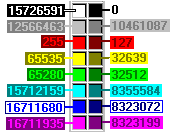
Color Numbers
Here are the integer values for some sample colors in RockWorks. See also the Color Converter in the Utilities | Widgets which will deliver the Windows integer number for any selected color.

RockWare home page