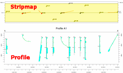
 Stripmaps are small, horizontally-oriented maps which depict the position of the logs within the profile. Stripmaps are positioned above or below the profile such that the horizontal axis of the stripmap is parallel to the profile diagram. The height of the stripmap is determined by the "swath" that is used when selecting the logs that will be included within the profile. Basically, stripmaps allow the user to visually determine the spatial relationship of a log relative to the projected section (profile).
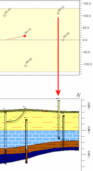
For example, consider the stratigraphic profile to the right in which DH-33 does not correspond to the interpreted stratigraphy. By looking at the stripmap, we can see that DH-33 is over 100 meters from the profile slice therefore indicating the the stratigraphy varies between DH-33 and the profile.
In the Borehole Manager, you can activate the display of the stripmap by inserting a check-mark in the Stripmap option. You can then expand that heading to access the map options.
Stripmaps can be appended to multi-profile diagrams as well as single diagrams.
 Stripmap
! You can also display distance labels on the profile diagram itself, to note the distance of each borehole from the profile. See the Show Collar Distances option.
![]()