RockWorks | Utilities | File | Import | NEIC
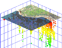
This program is used to import earthquake data from the USGS National Earthquake Information Center into the datasheet. When used in conjunction with the Utilitis | 3-D | Points program, this utility can be used to view earthquake data as color-coded (by depth), size-coded (by magnitude) global maps. The NEIC data must be ASCII space-delimited in format. Because there are a variety of data layouts available from NEIC, you can define within RockWorks the column locations of the different fields (coordinates, depths, magnitudes, etc.) The coordinates will be converted to your project coordinate system automatically.
Feature Level: RockWorks Basic and higher
Menu Options
Step-by-Step Summary
- Input File
- NEIC-File: Browse for the NEIC file to be imported.
- Options:
- Field Locations and Lengths
- Latitude: Specify the character position in the input file for the start of the earthquake latitude coordinates, and the character length of the latitude field. If the location is in the southern hemisphere, remember that the latitude will be preceded by a negative sign - be sure to note that as the start of the field. The best way to determine these positions is to open the NEIC file in a text editor or word processor, and to advance the cursor across a sample row, writing down the character position and length of each field. There may be missing fields from some records.
- Longitude: Specify the character position in the input file for the start of the earthquake longitude coordinates, and the character length of the longitude field. If the location is in the western hemisphere, remember that the longitude will be preceded by a negative sign - be sure to note that as the start of the field.
- Depth: Specify the character position in the input file for the start of the earthquake depth measurements, and the character length of the depth field.
- MB-Magnitude: Specify the character position in the input file for the start of the earthquake body-wave (MB) magnitude measurements, and the character length of this field.
- MS-Magnitude: Expand this heading to specify the character position in the input file for the start of the earthquake surface-wave (MS) magnitude measurements, and the character length of this field.
- Magnitude-1: Expand this heading to specify the character position in the input file for the start of the earthquake local magnitude measurements, and the character length of this field.
- Magnitude-2: Expand this heading to specify the character position in the input file for the start of the earthquake moment magnitude measurements, and the character length of this field.
- Output Options:
- Symbol: Click on the symbol box to choose a symbol for the imported records, which can be displayed in the datasheet. These symbols can be listed with varying colors by activating the Depth Coloring setting, below.
- Depth-Coloring: Insert a check in this box to have the program color-code the symbols automatically based on earthquake depth. This would record in different colors the symbols at the locations of deeper quakes than those for shallower ones. Expand this item to enter the depth to be set to the highest-color range.
- Max-Depth: Click on the Maximum Depth item to enter the greatest depth to be included in the cold-to-hot color scheme. Any deeper sites will be set to black. For example, if the maximum depth in the NEIC data set is 600 meters, you could enter "600" at this prompt to display the deepest samples in purple/pink, the shallowest in oranges/reds, and the intermediate samples colored blue -> yellow in between. If the maximum depth in the data set is 600 meters and you enter "400" at this prompt, then the samples at 600 -> 400 meters will be set to black, and the 400 -> 0 samples will grade from purple/pink to orange/red.
- Save Datasheet File: Check this box to assign a name to the datasheet file that will be created for the import. If you do not check this box, it will simply be displayed as Untitled.
- Output File Name:
- Automatic: Choose this to have the name of the file assigned automatically, using the name of the program plus a numbering digit.
- Manual: Choose this option to type a preferred name for the RwDat file into the prompt.
- Access the RockWorks Datasheet program tab.
- Create a new, blank datasheet by selecting the File | New | Blank menu option. Answer "Yes" or "No" as appropriate if you are prompted whether to save any existing data that's displayed in the RockWorks window.
- Select the File | Import | NEIC menu option.
- Establish the requested menu settings, described above.
- Click the Continue button to proceed.
RockWorks will import the NEIC data into the datasheet.
- Use the Utilities | 3-D | Points program to display the earthquake locations and magnitudes in 3d.
 Back to Importing Data

RockWare home page