Use this program to filter numeric data from the current datasheet based on settings you enter for up to 5 data columns. The rows that meet the filter requirements remain enabled (checked), the data that do not meet the filter requirements will be unchecked (disabled).
For example, you could set a filter for the X and/or Y data columns to extract a spatial subset of a larger data file. Or, you could set a filter for a particular elevation range for a formation column.
! This operates as an "AND" filter, not an "OR" filter. That means that only those records that meet all of the filtering criteria will be included in the output file.
! You cannot impose multiple filters on a single column.
! Only rows which are already enabled (checked) will be processed by this filter. Disabled rows will remain disabled regardless of their data listings.
Menu Options
Step-by-Step Summary
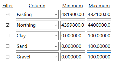
Here's an example in which the filtered subset will contain only those records with Easting coordinates between 481,900 and 482,100 AND Northing coordinates between 4,399,800 and 4,400,000. The items whose "Filter" box is not checked will not be processed.
The program will read through the enabled rows in the current datasheet. Those that do not meet all of the filtering parameters you established will be disabled.
![]() Back to Editing the Datasheet
Back to Editing the Datasheet
![]()