RockWorks | Graphics | Images | Legend: Add Image as Legend
This program:
- Reads a single image file.
- Creates a KML output file to display the image in the legend area of the Google Earth display, with no rescaling.
- Creates a KMZ (zip) output file, containing the KML and the image files.
- Loads the KMZ file in Google Earth. Legends remain fixed in size regardless of the zoom state of your view.
Feature Level: RockWorks Basic and higher
Menu Options
Step-by-Step Summary
- Image Name
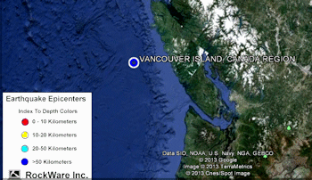
- Image Input File: Click to the right to browse for the image to be displayed as a legend in your Google Earth scene. This image should be fairly small in size, as it will be displayed at its native pixel size with no rescaling. For example, at 96 dots per inch on your screen, an image that is 96 pixels x 96 pixels will appear 1 inch by 1 inch in Google Earth. This program supports .BMP, .JPG, .PNG, .GIF, .TGA, and .TIF images.
- Group Name: Type in the name to assign to the legend, which will be displayed in the Google Earth data tree.
- Output Options: Click on this tab to define the output file and display settings.
- Output File Name
- Automatic: Choose this option to have RockWorks assign the name automatically. It will use the name of the current program plus a numeric suffix, plus the ".KMZ" file name extension.
- Manual: Click this option to type in your own file name. The extension is ".KMZ".
- Display output within Google Earth: Check this box if you want to display the output at this time in Google Earth.
! Note that the actual program which will be used to display the KMZ file is determined by your Windows settings.
- Use Custom View: If unchecked, the starting viewpoint for the legend will be determined automatically. If checked you can set a custom view.
- Longitude, Latitude: Type in the longitude and latitude coordinates where the viewpoint will be.
- Heading: Type in the 0 to 360 degree bearing from the viewpoint to the image.
- Tilt: Type in the angle downward from the viewpoint to the legend.
- Range: Enter the distance in meters from the viewpoint to the legend.
- Access the RockWorks Datasheet program tab.
- Select the RockWorks | Graphics | Images | Google Earth | Legend menu option.
- Enter the menu options as described above.
- Click the Contineu button to proceed.
The program will create a KML file containing a legend using the raster image you selected. It will create a KMZ file with the KML file and the image files. The Google Earth KML and KMZ file names will be assigned as you specified.
The resulting output will be displayed in Google Earth, if requested.
 Back to Image Menu Summary
"Google" is a trademark of Google Inc.

RockWare home page