The Graphics | Animate | Google Earth Flyovers | Command Driven menu option offers advanced flyover scripting using Google Earth commands. This topic discusses the command parameters.
- Open the "Animate_Earth_Flyover_Command.rwDat" sample file, installed in the \Documents\RockWorks Data\Samples folder for an example. Just File | Save As into your project folder and replace our sample data with yours.
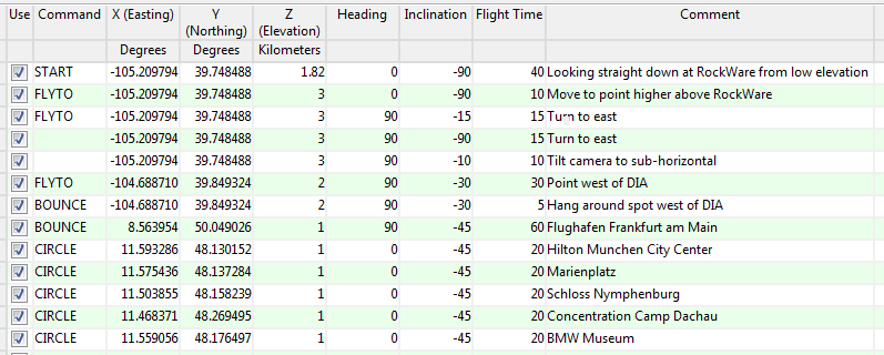
- Heading: The bearing, from 0 - 360, where the flight "camera" is pointing.
- Inclination: The camera angle, whereby "-90" is straight down and "0" is horizontal.
- Flight Time: The duration of the segment, in seconds.
- Command: You can choose from the following commands which drive the Google Earth flyovers.
- START: This simply defines the starting position for the flight. For this command you need to define:
- X , Y , Z (elevation) coordinates for the start of the flyover.
- Heading
- Inclination
- BOUNCE: This command creates a parabolic flight path between the previous point and the point you define here. You must define:
- X , Y , Z (elevation) for the end of the bounce.
- Inclination
- Flight Time from the previous point to this point.
- FLYTO: This command creates a straight flight path between the previous point and the point you define here. You must define:
- X , Y , Z (elevation) coordinates for the end of the segment.
- Inclination
- Flight Time from the previous point to this point.
- CIRCLE: This command circles around the previous point. You need to define the following. Note that the circle radius and duration is defined in the menu itself (for all circles in the flight).
- X , Y , Z (elevation) coordinates for the center of the circle
- Heading at the beginning of the circle segment
- Inclination
- Comment: You can include any comments in the listing, for your reference.

RockWare home page