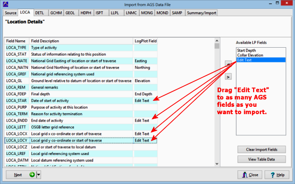
This step is used to define the location fields for the boreholes for the BH Info datasheet. Along the left you will see the fields in the AGS file and their descriptions. To the right you will see the available LogPlot fields. To map/unmap the LogPlot fields to/from the AGS fields, you can click and drag or select the item and click the "<" or ">" buttons.
- LogPlot will typically map the Easting, Northing, Elevation, and End Depth fields automatically. You can move any of these to a differnt input field as you wish, by clicking and holding the item with your mouse, and dragging to the desired AGS field.
! Not sure what's what? Click the View Table Data button to view the source data block. From there, you can click on the View Structure button to view the field definitions.
! LogPlot will automatically use the LOCA_ID or HOLE_ID fields for the name of the borehole data file to be created.
- Available LP Fields: Listed in this pane are other LogPlot BH Info fields which have not yet been mapped, possibly "Collar Elevation" or "Start Depth". Drag any additional LogPlot fields to the other AGS location details if you wish to import them.
- Edit Text: Also displayed will be an "Edit Text" item. You can drag this item to as many AGS Location Details as you want, to populate these fields in an Edit Text tab in the LogPlot data file. LogPlot will assign the Edit Text items the names listed in the Description column.
- Click the Next button to proceed to the next AGS data block.
Or, click on a tab at the top of the screen to select the next AGS data block to map.
Or, click on the small drop-down arrow by the Next button to jump directly to the next import screen of interest.
 Back to main topic | Next ( Lithology Data )

RockWare home page