- Click on the GEOL tab at the top of the import window to define the LogPlot fields to import.
- Choose the LogPlot Data Type for "Field Geological Descriptions" : Click the down-arrow here ("v") to select the "Lithology" datasheet.
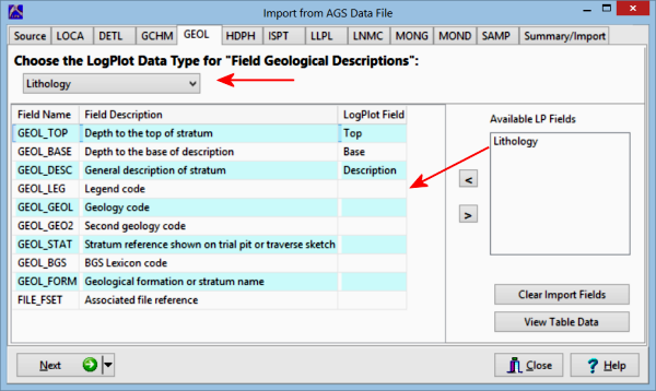
The importer will typically map the lithology Tops, Bases, and Descriptions automatically to the appropriate AGS fields.
- Available LP Fields: Lithology: Use your mouse to drag this field, representing Lithology Keywords, to the desired AGS field. Click the View Table Data button if you would like to look at the AGS data.
Note: The Geol_Leg (Legend Code) field contains a numeric code for the lithology types. If you select this item for your lithology keywords, LogPlot will deconstruct the numeric code (e.g. "101" to "Topsoil").
- Click the Next button to proceed to the next AGS data block.
Or, click on a tab at the top of the screen to select the next AGS data block to map.
Or, click on the small drop-down arrow by the Next button to jump directly to the next import screen of interest.
 Back to main topic | Next ( Point Data )

RockWare home page