"Land Grid" well descriptions are entered into the RockWorks Utilities datasheet using a Range, Township, and Section notation format. RockWorks can compute (or "spot") X,Y location coordinates for these descriptions using a commercial or idealized reference land grid as reference (Coords | Coordinate Converter (Multiple Points)). Once the wells have X,Y location coordinates, their locations can be displayed in a point map (Map | EZ Map).
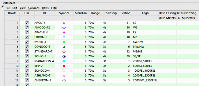
Example
Column Summary
- ID: Optional. Used to label wells in maps or other diagrams.
- Meridian: Required. RockWorks needs to know the Principal Meridian of the land grid survey in order to place the wells properly. This is defined using the BLM meridian numbers. By defining this column type as a "Meridian" column you can double-click in a cell to bring up an interactive meridian selection map. See Changing Column Titles and Styles for details.
- Symbol & Color: Optional. Handy if you wish to create point maps showing well locations.
- Range: Required. Must list the Range number followed by the letter "E" or "e" or "W" or "w", with no spaces separating the number and letter. The number must precede the letter. (The Range, Township, and Section declarations must be listed in separate columns.)
- Township: Required. Must list the Township number followed by the letter "N" or "n" or "S" or "s", with no spaces separating the number and letter. The number must precede the letter.
- Section: Required. Must list the Section number (1 - 36) in which the well is located.
- Location: Required. The well locations can be listed in either quarter/quarter format or in footage listings. Within these formats you have some flexibility as shown in the following.
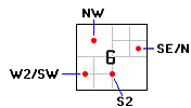
- Quarter/quarter format: Example: NW or SW or SE/SE or W2/SE or SESE or W2 SE or SE-SE or W2,SE or similar, as shown in the illustration below. Use upper- or lower-case characters. You may use spaces or slash (/) characters or commas within the description. You may also concatenate the descriptions (SESE)
- Offset format: Example: 250FSL,510FEL or 250fwl , 510fnl or similar. Footage descriptions must have a comma separating listings, not spaces alone. Footage descriptions may not include "/" or "-" characters. The footage label must immediately follow the number.
- Easting, Northing: Required. The program must have columns into which the computed X,Y coordinates may be recorded.
! Also required for translation of this type of well location description into X,Y is a "reference" land grid file that contains necessary section boundary coordinate information; download the RockWare Landbase from the RockWare web site.
Sample file: PLS_Points_to_XY_01.RwDat
See also

RockWare home page