 Estimated time: 1 minute.
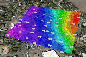
RockPlot2D contains a nifty tool for exporting map images to Google Earth, for display over your project area.
! It is necessary that you have completed the previous lessons before continuing. Click here to return to the beginning of this section.
! It is also necessary that you have Google Earth installed on your computer. Google Earth is not installed with RockWorks, and must be installed separately. Please visit www.earth.google.com for download and other information.
- Be sure the combined, annotated point + contour map is displayed in the active RockPlot window. This window should have the name "map with border.Rw2D."
- View the current coordinate projection: Click on the Utilities menu at the top of the Rockplot2D window, and select the Diagram + Projection Info option.
In this window, you'll see that RockPlot has classified this as a Map diagram. The XY Coordinates represent UTM Coordinates, in meters, using a NAD-83 Datum, Zone 13. All of this "metadata" is stored in the .Rw2D file. With this information, RockWorks can place the map at the correct location on the planet, in Google Earth.
! RockPlot2D also contains a reprojection tool - Utilities | Convert Coordinates - should you need to reproject your maps to a different coordinate system.
Click OK to close this window.
- Now, to export to Google Earth, just click on the large
 button on the toolbar above the map.
- Set the export options:
 Drape: Choose this option to drape the map image along the ground surface.
 Transparent Background: Check this option so that the white map background will be output as transparent.
- Click Process at the bottom of the export window.
- The program may display a prompt prior to transferring control to Google Earth - click OK to confirm the KMZ name that RockWorks will create, and confirm that you wish to launch Google Earth.
Google Earth should launch and your map be displayed.
- Adjust the Transparency of the map:
- Expand the "Rw2D Graphic" heading under Temporary Places, and right-click on the RW2D item displayed there. Choose the Properties option.
- Drag the Transparency slider bar to the left to increase transparency.
- Click OK when you're done.
- If you want to save this map to your Places in Google Earth, right-click on the "Rw2D Graphic" item under Temporary Places, and select Save to My Places.
- You can leave Google Earth open, or close it if you prefer.
 Exporting 2D Plot Files
 Back to RockPlot2D menu | Next (print the map)

RockWare home page