 Estimated time: 2 minutes.
In this lesson you will create a land grid section map based on the RockWare Landbase library. The section map can also be output to Google Earth.
 You cannot proceed here unless you have completed the previous lesson of the tutorial - downloading the large RockWare LandBase, the database of land grid location information. Be sure you’ve also accessed the Utilities program tab and opened the Samples project folder.
- Select the Map | Section Map menu option.
- Extents & Map Options: Click this Options button.
- Map Extents Defined By... (Extent tab)
 Range & Township: Select this option. This tells RockWorks that we are going to limit the map extents by specific townships. This is by far the fastest method. (Be warned in your own work - setting map extents via Project Dimensions or Longitude/Latitude are very very slow.)
- Principal Meridian: This should be set to: 6th Principal
If it is not, click on this button and click on the radio button in eastern Kansas. You will be returned to the menu with the Principal Meridian set to "6th Principal".
- Ranges:
- Westernmost Range: Click on this item and type in: 70W
- Easternmost Range: Click on this item and type in: 69W
- Townships:
- Southernmost Township: Click on this item and type in: 4S
- Northernmost Township: Click on this item and type in: 3S
 Clip to Project Dimensions: Unchecked
- Map: Click on this tab at the top of the window to establish the appearance settings:
 Section Borders: Insert a check in this check-box so that the section lines will be plotted.
- Line Style & Color: Click the small line sample to the right to set the line style to thin, and the color to red.
- Fill Sections: Uncheck this.
- Section Labels: Check this box.
- Verbose: Remove this check-mark so that the labels will be short in length.
- Include Acreages: Remove this check-mark also.
- Font Size: 15 (representing a percent of the size of the section).
- Font Color: red.
- Opaque Background: uncheck this.
- Township Borders: Insert a check here.
- Line Style & Color: Click the small line sample to the right to set the line style to thicker, blue lines for the Township boundaries.
- Fill Townships: Uncheck this.
- Township Labels: Check this box.
- Show Township Fractions: Uncheck this
- Verbose: Uncheck this so that the labels will be short in length.
- Font Size: 30
- Font Color: black
- Opaque Background: uncheck this.
- Labeling Convention:
- Township/Range: Click in this button. This just tells the program to plot the Township label first.
- Click OK to close the Extent & Map Options window.
- Border: Uncheck this option.
- Click Process at the bottom of the Land Map window.
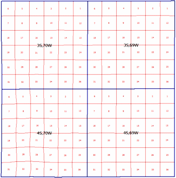
The program will read the location information from the LandBase and create a map illustrating the four selected Townships, each with 36 sections, and display it in a 2D plot window ("RockPlot2D"), where "flat" maps, logs, and other diagrams are displayed. The output map will use the project coordinate system and units.
- Save the map:
- Choose the Save command from the RockPlot File menu.
- In the displayed prompt, enter the file name: reference-grid and click the Save button. The program will stored the map under that file name, with an ".Rw2D" file name extension.
- If you have Google Earth installed on your computer and would like to display this map in that program, click the Google Earth button
 at the top of the map window.
! Note that Google Earth is not installed with RockWorks; please visit www.earth.google.com for download and licensing information.
In the displayed options window, choose the following options.
- Drape: Click in the button - the map will lie along the ground surface in Google Earth.
- Transparent Background: Check this box so that the white map background is set to transparent.
- Click Process at the bottom of the window.
- If RockWorks displays a window confirming the output KMZ file name, click OK.
- Your map should be displayed as draped along the ground surface in the project area.
- If you would like to save this map in Google Earth, right-click on the Rw2D Map item under Temporary Places, and select Save to My Places.
- Back at RockWorks, you can close the map window using the close button (
 ) in the upper-right corner.
 Section Maps
 Back to land grid menu | Next (spot RTS wells)

RockWare home page