RockWorks | Borehole Manager | File |
Transfer | Stratigraphy -> Utilities Datasheet
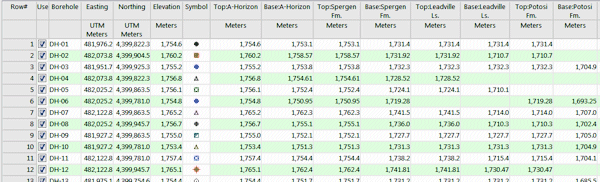
This program will populate the current datasheet in the Utilities program tab with the top and base elevations for each stratigraphic unit for all boreholes in the Borehole Manager. The datasheet will be built with a specific column order, with the stratigraphic unit names pulled from the current Stratigraphy Types Table. This can provide an easy method for viewing and editing all stratigraphic information. (See also Transferring Stratigraphy to the Borehole Manager for information about how to transfer it back.)
! The tops and bases for the stratigraphic units, when transferred, will be listed as elevations - not depths.
! This program assumes that all holes are vertical. Otherwise, it's conceptually impossible to list stratigraphic contacts in a datasheet format.
Menu Options
There are none.
Step-by-Step Summary
The program will read the contents of the current Stratigraphy Types Table as well as the Stratigraphy data table for all boreholes. It will translate all stratigraphic depths to elevations, in your output units, and list the information to columns in the Utilities datasheet. That datasheet will be brought to the front. Exported fields include borehole ID, Easting, Northing, surface elevation, borehole symbol, and then the top and base elevations of each stratigraphic unit, listed from left to right in the same order as the units are listed top -> down in the Stratigraphy Type Table. Coordinate system and units will be reflected in the column headings.
![]()