Log clipping provides a means of displaying a subset of each log's data, based on a user-entered elevation range. This can be helpful if you have a very deep project and wish to focus a particular diagram on particular vertical subset of the data. Note that the clipping should clip all log entities except the title.
These settings are accessible in all RockWorks options windows where the Plot Logs option is displayed - all Borehole Manager striplog, profile, section, and fence diagram windows.
2D Log Clipping
3D Log Clipping
Menu Options - 2D Log Diagrams
- Plot Logs: This is the main option in the menus which, if checked, triggers the plotting of logs in the diagram.
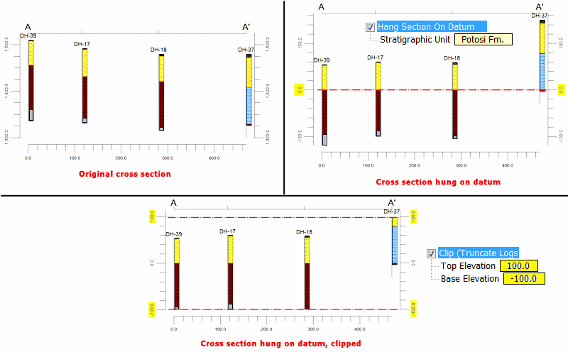
- Clip (Truncate Logs): Check this box to turn on the clipping of your logs.
- Top Elevation: Click on the displayed value to specify the uppermost elevation to be represented in the log, log section, or multiple log diagram. Note that this value must be entered as an ELEVATION rather than a depth.
- Base Elevation: Click on the displayed value to specify the lowest elevation to be included in the log, log section, or multiple log diagram.
If you are creating a striplog cross-section (Striplogs | 2-Dimensional | Multi-Log Section) you have the option of hanging the section on a stratigraphic formation. ! If you activate this, take note that you'll need to adjust your clipping elevations to be based on the new zero-datum elevation.
Menu Options - 3D Log Diagrams
- Plot Logs: This is the main option in the menus which, if checked, triggers the plotting of logs in the 3D diagram.
- Clip (Truncate Logs): Check this box to turn on the clipping of your logs. Note that the clipping coordinates you enter for any of the X, Y, or Z axes will clip portions of logs for non-vertical holes.
- X (Easting) Clipping: Check this box to omit log data based on the X coordinate of the data. Expand this heading to enter the clipping coordinates.
- X-Min (Western Border): Click on the displayed value to enter the westernmost coordinate to include in the diagram.
- X-Max (Eastern Border): Click on the displayed value to enter the easternmost coordinate to include in the diagram.
- Y (Northing) Clipping: Check this box to omit log data based on the Y coordinate of the data. Expand this heading to enter the clipping coordinates.
- Y-Min (Southern Border): Click on the displayed value to enter the southernmost coordinate to include in the diagram.
- Y-Max (Northern Border): Click on the displayed value to enter the northernmost coordinate to include in the diagram.
- Z (Elevation) Clipping: Check this box to omit log data based on the elevation of the data.
- Top Elevation: Click on the displayed value to specify the uppermost elevation to be represented in the 3D log diagram. Note that this value must be entered as an ELEVATION rather than a depth.
- Base Elevation: Click on the displayed value to specify the lowest elevation to be included in the 3D log diagram.

RockWare home page