RockPlot2D File | Export | KMZ (Google Earth) Map
or
RockWorks | Utilities | Grafix | 2D Utilities | Export | KMZ
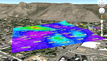
Use this program to save an existing map (Rw2D image) into a Google Earth KMZ (Keyhole Markup Language - Zipped) file. The result is your RockWorks map displayed in Google Earth. Since RockPlot2D maps are now geo-referenced, there are very few settings that need to be established.
Menu Options
Step-by-Step Summary
Menu Options
- Rw2D Input File: (Grafix menu only.) Click to the right to select the name of the Rw2D file to be exported to KMZ format. This file must have already been saved in the RockPlot2D window. See Saving RockPlot2D Images.
- Elevation:Use these settings to define where the map will be placed vertically in Google Earth.
- Clamped to Ground: Choose this option to lay the map on the ground surface in Google Earth.
- Float: Choose this option to float the map above the ground surface in Google Earth.
- Elevation (meters): Click to the right to type in the absolute elevation at which the map will float, in meters. (This does not represent elevation relative to the ground, but elevation relative to sea level.)
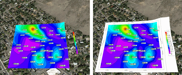
- Transparent Background: Check this option to have the background color in the image be set to fully transparent. In the example below, the map on the left was generated with Transparent Background turned on.
Note that you can also apply transparency to the map as a whole once it's plotted in Google Earth.
Step-by-Step Summary
- From RockPlot2D: If necessary, open the Rw2D file you wish to export (see Opening Plot Files) or save the current plot if it's untitled (see Saving RockPlot2D Images). Be sure to use the Layers pane to turn on/off the items you do/don't want to have displayed in the output.
- Select the File | Export | KMZ (Google Earth) Map command from the RockPlot2D menu.
- OR -
From the RockWorks Utilities program tab, select the Grafix | 2D Utilities | Export | KMZ (Google Earth) menu option.
- Enter the requested menu item, as described above.
- Click the Process button to proceed.
The program will create a KML file containing the map image. It will create a KMZ (zip) file containing the KML file. The Google Earth KML and KMZ file names will be assigned automatically.
- If RockWorks displays the KMZ name in a popup window for your reference, you can confirm:
- Automatically load file into Google Earth: Be sure this is checked if you want to display the output at this time.
- Show this message every time a KMZ File is Created: If checked, this window will be displayed each time a Google Earth output is created. Uncheck this if you prefer not to see this window in the future.
(Both of these settings are also available via the Preferences menu.)
- Click OK to continue or Cancel to cancel the operation.
The resulting map will be displayed in Google Earth, if requested.
 Back to Export menu

RockWare home page