RockWorks | Utilities | Grid | Statistics | Report
This program is used to get a general summary of the contents of an existing grid model. The statistical summary is displayed as a textual report, in which the summary of node values and computed statistics are displayed.
You can use the statistical summary in a variety of ways: If you are performing mathematical operations with two grid files, you can create a summary of each to assure that they have the same dimensions and numbers of nodes. If you are creating grid models of the same data using different modeling methods, you can create a summary of each model to view the differences in the range of the Z-values.
! This utilities is also available by right-clicking on an .RwGrd file name in the Project Manager and selecting View Grid Statistics.
Menu Options
Step-by-Step Summary
The program will read the indicated grid model and compute the general statistics. The statistical summary will be displayed in a Text tab in the Options window.
From here you can print the information, copy it to the clipboard for pasting into another application, save the information on disk, etc.
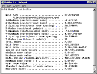
Here's an example of a report:
Grid Name .............................. D:\Documents\RockWorks17 Data\Samples\A-Horizon_top.RwGrd
File date .............................. 4/22/2015 9:04:52 AM
Dimensions:
X-Minimum (western-most node) .......... 481,875.0
X-Maximum (eastern-most node) .......... 482,175.0
X-Spacing (east/west node spacing) ..... 5.0
X-Nodes (east/west points) ............. 61 Nodes
Y-Minimum (southern-most node) ......... 4,399,725.0
Y-Maximum (northern-most node) ......... 4,400,025.0
Y-Spacing (north/south node spacing) ... 5.0
Y-Nodes (north/south points) ........... 61 Nodes
Total Nodes ............................ 3,721 Nodes
Univariate Node Statistics:
Population (Non-Null) ................... 3,721
Null Population (Value = -1.0e27) ....... 0
Minimum Value ........................... 1,752.26
Maximum Value ........................... 1,768.14
Range ................................... 15.88
Mean .................................... 1,757.73
Standard Deviation ...................... 4.16
Standard Deviation Error ................ 0.07
Average Deviation ....................... 3.5
Median .................................. 1,755.96
Sum ..................................... 6,540,504.65
Sum of Squares .......................... 11,496,490,437.2
Variance ................................ 17.33
Skewness ................................ 0.95
Kurtosis ................................ -0.4
Coefficient of Variation ................ 0.0
Population > Zero ....................... 3,721
Lowest Value > Zero ..................... 1,752.26
Statistical Classification Thresholds:
Mean - 1 Standard Deviations ......... 1,753.56
Mean + 1 Standard Deviations ......... 1,761.89
Mean - 2 Standard Deviations ......... 1,749.4
Mean + 2 Standard Deviations ......... 1,766.05
Mean - 3 Standard Deviations ......... 1,745.24
Mean + 3 Standard Deviations ......... 1,770.22
Mean - 4 Standard Deviations ......... 1,741.08
Mean + 4 Standard Deviations ......... 1,774.38
Statistical Classification Populations:
Background (Mean +/- 1SD) ............ 2,739
Slightly Anomalous (Mean +/- 2SD) .... 750
Moderately Anomalous (Mean +/- 3SD) .. 232
Strongly Anomalous (Mean +/- 4SD) .... 0
Extremely Anomalous (Mean +/- 5SD) ... 0
Area/Volume:
Center of Mass (x,y) ................... 482,025.177099 , 4,399,875.070513
Cell Area .............................. 25.0
Map Area (X*Y) ......................... 90,000.0
Grid Area (Sum(Cell Area)).............. 93,025.0
Model Volume (Sum(Cell Area*Z)) ........ 163,512,616.164424*
Non-Zero node area ..................... 93,025.0
Projection Information:
XY (Horizontal) Units .................. Undefined
Z (Vertical) Units ..................... Undefined
* Volumetric, slope, aspect, and strike computations assume that the z-values for the grid nodes represent linear dimensions (i.e. elevations or depths in meters or feet). These numbers do not apply to grids in which the z-values represent geochemical, geophysical, geotechnical, etc. properties.
Notes (Metadata)
![]() Back to Grid Menu Summary
Back to Grid Menu Summary
![]()