RockWorks | Datasheet | File | Import | Garmin TXT
This program is used to import the data from Garmin MapSource "txt" files into the RockWorks datasheet. In the process, the program will convert the longitude/latitude positions to UTM (Universal Transverse Mercator) coordinates.
Menu Options
Step-by-Step Summary
- Input File: Click here to browse for the text file containing the GPS tracks or waypoints.
- Format Options:
- Input Format: Use these settings to define the format for the input data.
- Longitude/Latitude: Choose how the input coordinates are recorded by clicking in the appropriate radio button.
- Elevation Units: Choose the units for the input elevation measurements by clicking in the appropriate radio button.
- Import Type: Select the type of data you are importing
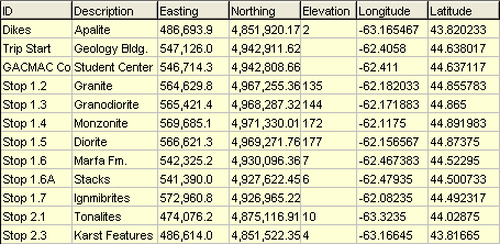
- Waypoints: If you choose this option, the program will create a datasheet that contains the waypoint ID, description, easting (calculated), northing (calculated), elevation (from GPS), longitude (from GPS), and latitude (from GPS) data.
-
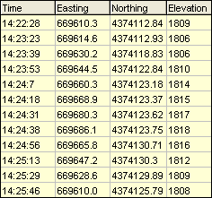
- Tracks: If you choose this option, the program will create a datasheet that contains the GPS time, easting, northing, and elevation, as shown within the following example.
-
- Output Format
- Elevation Units: Choose the units for the output elevation measurements by clicking in the appropriate radio button.
- Access the RockWorks Datasheet program tab.
- Select the File | Import | Garmin TXT option.
- Enter the program settings, as described above.
- Click the yellow Process button to proceed with the import.
The program will read the input file, translate the coordinates using the defined projection, and record the information into the datasheet.
- Save the imported data (File | Save).
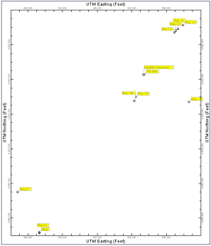
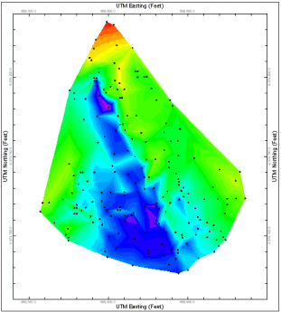
Tips: The imported data can be mapped using many of the Map menu programs, including Point Symbol and Triangulation Contours:
 Back to Importing Data

RockWare home page