RockWorks | Utilities | Earth | Survey to Points
This program:
- Reads a listing of data from the Datasheet: XY locations for control points, and bearing and distance measurements to various survey stations.
- Calculates the XY locations for the survey stations.
- Creates a KML output file with icons at those XY locations.
- Creates a KMZ (zip) output file, containing the KML file.
- Loads the KMZ file in Google Earth.
Feature Level: RockWorks Basic and higher
Menu Options
Step-by-Step Instructions
- Data Columns: The prompts in this tab tell RockWorks which columns in the input datasheet contain the required data.
Click on an existing name to select a different name from the drop-down list. See a sample data layout below.
- Station #: Column that contains the station numbers.
- Description: Column that contains the station descriptions.
- Station X: Column that contains the X coordinates for the control points.
These can be Eastings in meters or feet, decimal longitudes, etc. See Defining your Datasheet Coordinates for more information.
- Station Y: Column that contains the Y coordinates for the control points.
- "From" Station: Select the column in the datasheet that lists the station number FROM which the survey measurement was taken.
- "To" Station: Select the column in the datasheet that lists the station number TO which the survey measurement was taken.
- Bearing Column: Select the column in the datasheet listing the compass bearings from the "from" station to the "to" station.
- Distance Column: Select the column in the datasheet listing the distance from the "from" station to the "to" station.
Be sure you've defined the linear units for these distance measurements. See Defining your Datasheet Coordinates.
- Include Descriptions: Check this box to include the station descriptions in the output file.
- Output Options: Click on this tab to define the output file and display settings.
- Output File Name
-
- Automatic: Click this option to have RockWorks assign a name to the KMZ file which will be generated for display in Google Earth.
- Manual: Click this option to type in your own file name. The extension is ".KMZ".
- Display output within Google Earth: Check this box if you want to display the output at this time in Google Earth.
-
- Use Custom View: If unchecked, the starting viewpoint for the map will be determined automatically. If checked you can set a custom view.
-
- Longitude, Latitude: Type in the longitude and latitude coordinates where the viewpoint will be.
- Heading: Type in the 0 to 360 degree bearing from the viewpoint to the map.
- Tilt: Type in the angle downward from the viewpoint to the map.
- Range: Enter the distance in meters from the viewpoint to the map.
- Access the RockWorks Datasheet program tab.
- Create a new datasheet and enter or import your location coordinates and other information into the datasheet.
Or, open one of the sample files and replace that data with your own.
! Click the Example button at the top of the window to load a sample file that is installed with the program.
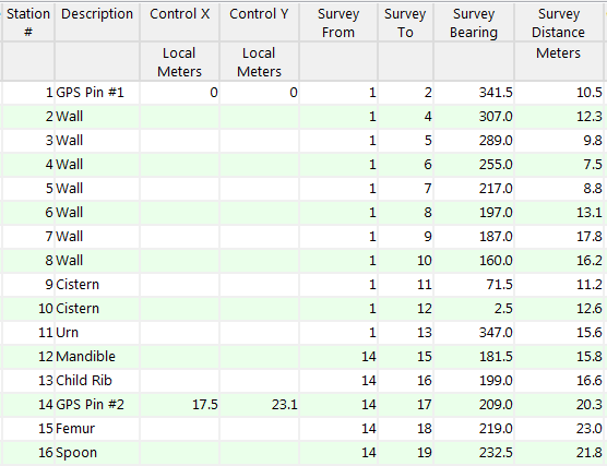
Here is an example of how a data file might look.
If you've defined your control points using longitude and latitude coordinates, they must be in decimal format. If you're using another coordinate system, be sure you've specified the Units and the Projection Settings as appropriate.
- Select the RockWorks | Utilities | Earth | Survey to Points menu option.
- Enter the menu options as described above.
- Click the Continue button to proceed.
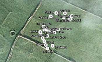
RockWorks will determine the locations of the survey stations based on the control points. It will create a KML file with icons at each station, with labels as requested. It will create a KMZ (zip) file containing the KML file. The Google Earth KML and KMZ file names will be assigned as you specified.
The resulting map will be displayed in Google Earth, if requested.
 Back to Earth Menu Summary
"Google" is a trademark of Google Inc.

RockWare home page