Introduction
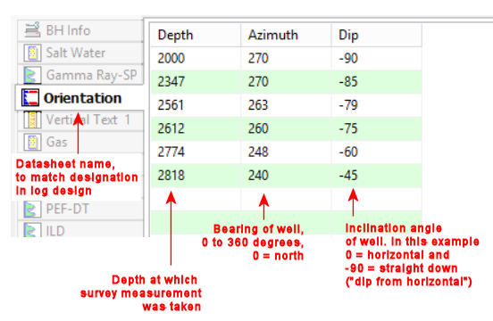
Example
How to enter the Orientation Data
Use: The LogPlot Orientation datasheet is used to enter downhole survey information for non-vertical wells. This information can be reflected on a strip log scale bar that’s linked to the Orientation data tab, or displayed in a Curve column showing true vertical depth.
! LogPlot logs are plotted as vertical, but the true elevations for any well deviation can be reflected on the scale bar.
Corresponding log design component: Downhole survey information will be represented on the log in an elevation scale bar that is linked to this data tab. It can also be represented in a Curve column set up to display true vertical depth.
Corresponding RockWorks data table: Orientation
Right-Click Options: When you right-click in any of the Orientation datasheet's cells, you have the following options:
Cut, Copy, Paste Insert/Append/Delete Rows Manipulate Columns Fill Depth Column Edit Data Page Name Delete Data Page Move
Automatic:
If there’s already a Scale Bar or TVD Curve Column in the current log design that is set up to display true vertical depths or elevations, with a name defined, you can use the Data | Update Data File from Log Design tool to insert an Orientation datasheet in the current data file. The program will know how to name the tab based on the log design information.
Manual:
You can also use the Data | New Data Page | Orientation menu option to manually insert a datasheet.
New Name: Type in the name to assign to the datasheet. LogPlot will use this name to match data to the item(s) in the log design.
Click OK.
The program will add to the data file an Orientation datasheet labeled with the selected name, and with 3 blank columns: Depth, Azimuth, and Dip.
Depth: Enter here the depths at which the downhole survey measurements were taken.
Bearing: Type in the bearing of the well at the listed depths. The bearings must be expressed in azimuth degrees (0 to 360, with 0 = north).
Inclination: Type in the inclination of the well at the listed depths. The inclination data follows either:
a "dip from horizontal" convention in which 0 is a horizontal line, -90 points straight down, and +90 points straight up, or a
a "dip from vertical" convention in which 0 is straight down and +90 is horizontal. (The data convention is established in the log design.)
There is no limit to the number of survey points you can list for the well.
Survey data must be listed in order, from the start of the well to the end.
![]() Back to Datasheet Summary
Back to Datasheet Summary
![]()