Borehole Manager | File | Import | Excel | Multiple Tables
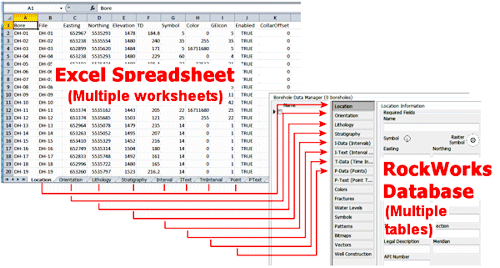
Use this tool to bring data into the Borehole Manager from multiple worksheets in an external Microsoft Excel file, for one or more boreholes and a variety of data types. Each worksheet in the XLS file must contain a specific type of data (locations or stratigraphy, for example).
(By contrast, if you wish to import data from a single Excel worksheet into a single data table, see the File | Import | Excel | Single Table tools.)
A few important notes about the Borehole Manager | File | Import | Excel | Multiple Tables importer:
- The Excel import tool can append to existing borehole records. This means that data being imported that references existing borehole names can be written to the existing record's fields.
Example: If your existing database contains Location and I-Data records for DH1 and DH2, you can append Lithology data for those same boreholes.
Example: If your existing database contains T-Data for one sampling event, and you'd like to add it for a second sampling event, then you can simply import the T-Data into the database without referencing a Locations worksheet. WARNING: The program does not check for duplicates during the import process.
- You can append new boreholes to the project via the Excel import. If your XLS file references borehole names not already present in the project, it will create new borehole records, and bring in data for those boreholes. This can be an efficient way to merge projects.
Example: If your existing database contains data for DH1 and DH2, you can import data for DH3 and DH4 and those new borehole records will be created.
- You cannot, however, append to existing Lithology, Stratigraphy, Aquifer or Well Construction tables for individual boreholes.
Examples: If you have lithology data for DH1 for depths 0-50 in the database, importing lithology data for DH1 for depths 50-100 from the Excel file will replace all of the existing lithology data for that borehole.
- Be warned that there is no easy way to completely replace the I/P/T data in a database (if the Update Overwrite option is selected, data is always appended). If you need to do this, we would recommend that you export all of the tables in a database to an Excel file, modify the data that needs to be replaced, and then re-import all of the data with the "Replace" overwrite option selected.
- If the Location table is not mapped, I/P/T Data is always appended, regardless of the Overwrite option selected. Data such as Lithology and Stratigraphy is always overwritten.
- The format of the imported spreadsheet must be the same as that produced by the export-to-Excel (File | Export | Multiple Tables) program - there is a specific layout that RockWorks requires. See Excel File Format for details.
- Because of the relational nature of the RockWorks database tables, it is necessary for the data types to be defined so that the import tool will be able to bring all of your Excel data into the database.
Example: If you are importing downhole interval measurements for "Benzene" and "Toluene", these I-data field names need to be defined so the import tool knows where to put them. There are three ways to do this:
- (Recommended) Include the Type definitions - lithology, stratigraphy, well construction, I-Data, I-Text, T-Data, P-Data, P-Text - in the Excel spreadsheet itself. See the discussion of the Types worksheets in the Excel File Format topic.
- Define them in RockWorks before you import the Excel data. Use the Project Manager to access the Project Tables | Types Tables where you can create/modify the defined data types. (You can also access the Types tables using the buttons on the data tabs themselves.)
- Let the import tool define them on the fly.
Note that you will then need to view the Types Tables to establish patterns, colors, data ranges, etc.
Note that Stratigraphy Types would be added to the Types Table in the order they are encountered in the input file. After import, you will need to edit the Order field for Top -> Down formation order.
- If the borehole locations in the file being imported are defined with a different coordinate system or units, they can be converted to your project coordinate system during import. Note that if RockWorks performs this conversion, UTM coordinates will be rounded to 2 decimal places.
Topics
See also

RockWare home page